|
DOI: 10.7256/2453-8922.2022.3.39001
EDN: GJEIUY
Received:
22-10-2022
Published:
31-10-2022
Abstract:
The subject of the study are soils on the territory of the Khanovey educational field training site in the Vorkuta district of Komi Republic. Morphological descriptions of soil profiles and diagnostics and classification of soils in the modern Russian system were carried out. Laboratory analysis was carried out to determine soil properties: moisture content, acidity and total content of soluble salines. The study area is located in the southeastern part of the Bolshezemelskaya tundra, it is represented by inclined surface of the right side of the valley of the Vorkuta River valley, composed of alluvial and ancient alluvial sands, overlain by loamy and sandy-loam deposits. Holocene peatlands up to 4–5 m thick are the youngest deposits within the studied territory. Small and large dwarf birch tundras with shrub-green moss and grass-shrub-sphagnum cover are common here. The studied soils belong to the division of organogenic, postlitogenic and synlitogenic soil formation. The first includes oligotrophic peaty soils within a thick peatland (Histosols), the second includes cryogenic and cryometamorphic soils (Cryosols), as well as peaty gleyzems (Histic Cryosols). The third includes alluvial humic soils (Fluvisols). The moisture content of soils varies widely from 2 to 900 %. Soils acidity is from acidic to neutral (pH 4.5 to 7.5). The content of soluble salts in soils varies from about 0 to 300 mg/l.
Keywords:
soils, permafrost, acidity, the content of easily soluble salts, organic matter content, carbonate alkalinity, palsa, Khanovey educational field training site, Vorkuta district, Komi Republic
This article is automatically translated.
You can find original text of the article here.
Introduction The Khanovey educational and Scientific training ground (UNP), located on the slope of the Vorkuta River valley adjacent to the Northern Railway track, in the area of the Khanovey railway station of the same name (Fig. 1) has been studied in great detail from the engineering-geocryological and geological-geophysical points of view. Over the past few years, work has been regularly carried out here to study the properties of seasonally thawed and frozen soils, soil thermometry [25, 29, 26]. Various geophysical methods are used to study the capacities, composition and properties of sediments at the landfill, mainly to establish the depth of the sole of the seasonally thawed layer (STS) during the period of its deepest thawing per year (beginning – mid-September)[27]. Landscape descriptions are also produced here annually, which, however, have a very significant geobotanical emphasis, while descriptions of soils, soil-landscape relationships and the structure of the soil cover are few here. These, in fact, include only the works of N.A. Budantseva with co-authors [3] and the dissertation of I.N. Semenkov[20], in which, for the first time in this particular area, the issues of the profile structure of soils, their morphological and chemical properties, as well as the catenary organization of the soil cover were considered. Also, Yu.K. Vasilchuk and co-authors[4] laid and studied the soil-geochemical catena in the landscape conditions very close to Hanovei in the vicinity of the village of Yeletsky (also Vorkuta district of the Komi Republic). The remaining data on soils and soil cover of the territory near Vorkuta have either a smaller scale [1,14], or are localized at other points on a very extensive and heterogeneous territory of the district [9,19]. There is a need for a detailed study of the profile structure and properties of soils, as well as soil-geochemical catenae for further use of these data in the study of radial and lateral migration flows of chemicals on the territory of the Khanoveysky landfill. Also, a comprehensive study of the landscape structure and its features will be able to help researchers in clarifying ideas about the history, agents and factors of the development of the relief of this territory, which are a debatable issue in the community of geocryologists of Russia. Finally, the studied soil properties in detail are able to correct the construction of future landscape maps used in the organization of long-term monitoring points of the ecosystem. Soil-geochemical studies were carried out by the authors of the article at the Hanovey landfill in September 2022. In the course of the research, 10 soil sections were laid directly on the territory of the landfill and beyond, 42 soil samples were selected according to genetic horizons. Morphological properties of soil profiles are described according to the rules of classification and diagnostics of soils in Russia[11]. Chemical and physico-chemical properties of soils (pH, TDS) were studied in laboratory conditions. Physical and geographical conditions of the research areaGeographical location of the Khanoveysky educational and scientific training ground The Khanoveysky educational and scientific training ground (67°17'9.05" s.w., 63°39'25.38" v.d.) is located in the Vorkuta district of the Komi Republic. The distance to the center of the landfill southwest of Vorkuta is 28.8 km. The territory of the landfill with an area of approximately 0.5 km 2 adjoins from the east to the section of the Moscow – Vorkuta railway (Northern Railway) in the area of the Hanovey station in the village of the same name (67°16'58.93" s.w., 63°39'0.89" v.d.). The distance from the station to the center of the landfill is approximately 500 m. From the west, the territory of the landfill is bounded by the railway line, from the east by the Vorkuta River. 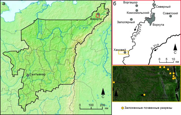
Fig. 1. The location of the Khanoveysky landfill on the territory of the Komi Republic (a) and the Vorkuta district (b) and the landfill itself with the adjacent territory (c) Geological structure and relief of the south-east of the Bolshezemelskaya tundra The territory of the Komi Republic is a combination of several large orographic elements, among which the largest area is occupied by the vast Pechora lowland, confined to the valleys of the Pechora and Usy rivers. The Khanoveysky UNP, which is part of the Pechora Lowland, is located in its northeast in the upper reaches of the river. Mustache [13]. The geological section of the territory of the north-east of Komi reveals rocks of various composition and thickness. The most ancient are the deposits of the early Precambrian with an age of more than 2 billion years [23], quaternary deposits [24], represented by boulder loams and sands, as well as alluvial and lake-marsh sands, sandy loams and loams (Table 1)[7]. The main macroforms of the relief (orographic elements) correspond to the irregularities of the roof of pre–quaternary deposits, while the modern mesorelief was formed under the active action of exogenous factors - erosion and accumulation[8]. The northern part of the Pechora Lowland belongs to the territory of the Bolshezemelskaya tundra. The characteristic forms of mesorelief for this territory are elongated hills of the ridge type ("musyura") with relative heights of 40-50 m, composed of loam. The valleys of large and medium-sized rivers (Pechora, Usy, Vorkuta, etc.) are wide, well-developed, the riverbeds are trough- and box-shaped in profile. Lateral erosion of the shores prevails at a rate over deep erosion. The slopes of the river valleys are gentle, repeatedly complicated by combinations of frozen thermokarst depressions with convex-bumpy peat massifs (Fig. 2, a, Table 1). Peat and peat-mineral heave mounds (palza) with heights from 1.5 to 7 m are widespread here (Fig. 2, b). 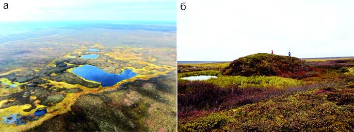
Fig. 2. Overgrown thermokarst depressions in combination with swampy interbug depressions and elevated surfaces of convex peat mounds (a) (photo by D.O. Sergeev from the DJI Mavic Air – 3 UAV) and a convex peat bulge of heaving - palza, about 7 m high, turning into an overgrown interbug depression (b). Photo by A.P. Ginzburg Table 1. Areas of soil-forming rocks on the territory of the Komi Republic [1]
| Soil - forming rocksArea, thousand hectares | % of the area of the Komi Republic | Loamy moraines | | | 7902 | 19,16 | | Loamy cover (powdery) | 3562 | 8,64 | | Sandy loam | 14 | 0,03 | | Sandy | 4414 | 10,70 | | Sandy loam, underlain by moraine-like loam | 4858 | 11,78 | | Sandy, underlain by moraine-like loam | 7936 | 19,24 | | Loamy, underlain by sands |
104 | 0,25 | | Loamy, underlain by crystalline bedrock | 13 | 0,03 | | Eluvium of crystalline bedrock (low-power loamy-gravelly) | 4106 | 9,96 | | Modern alluvium of floodplain terraces (mostly sandy) | 2744 | 6,65 | | Peat bogs of upland and lowland bogs | 5591 | 13,56 | Geocryological features Permafrost rocks (MMP) are widespread in the north and northeast of the Komi Republic, the southern border of which runs approximately along the Arctic Circle (66°33’s.w.), in the northeast moving southward almost to the latitudes of the cities of Usinsk and Inta (approximately 66°02’s.w.), and along In the Polar Urals, the area of its distribution stretches to 61 °S., south of Syktyvkar [6]. The formation of the cryolithozone in this region corresponds to the late Pleistocene (about 126-11.7 thousand years ago). During subsequent geological epochs, permafrost rocks repeatedly degraded and agraded, but have not completely disappeared since then[2,15]. 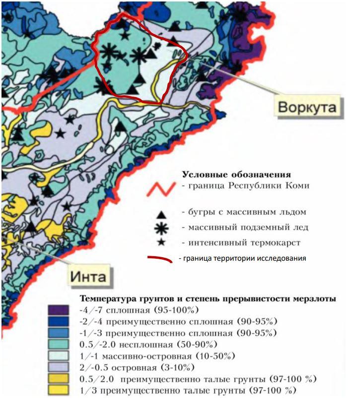
Fig. 3. Fragment of the GIS layer "permafrost in the basin of the Usa river"[28]
Permafrost rocks in the southeastern part of the Bolshezemelskaya tundra have a discontinuous (50-95% of the area) and massively insular (10-50% of the area) distribution. The temperatures of the rocks of the discontinuous distribution have values from 0.5 to -2.0 ° C, rocks of the massively insular distribution - from 1 to –1 ° C (Fig. 3). The maximum thickness of the seasonal melt layer of the seasonal (STS) here reaches 1-1.2 m on peat bogs and 1.5–1.7 m on mineral rocks. In the course of field studies of soils, we encountered very contrasting conditions of the depth of permafrost within the small territory of the Khanovei UNP: under powerful peat bogs (0.4 m and more powerful), the depth of the STS did not exceed 0.5–0.7 m, under the litter-peat horizons of low-power soils, the MMP lay at depths of about 1.2–1.4 m, and on open areas of the territory, generally devoid of vegetation and organogenic soil horizon, such as, for example, arrays of tundra spots-medallions (Fig. 4, a, b) the depth of the roof of the MMP was not reached at all. Presumably, within these areas it is 2 m or more. Sandy alluvial deposits on the floodplain terraces and floodplains of the Vorkuta River are completely thawed. 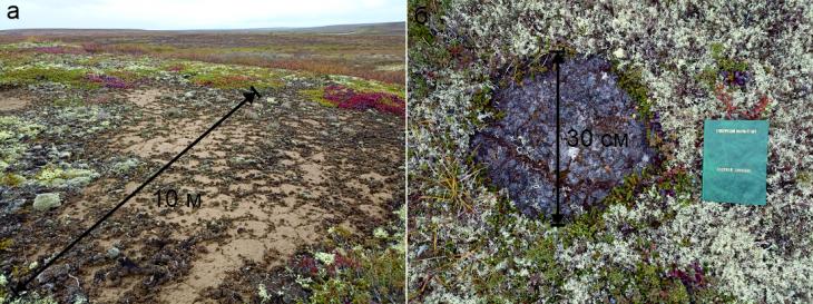
Fig. 4. Large arrays of medallion spots, almost devoid of vegetation cover (a), and single round tundra medallion spots (b) on UNP Hanowei (photo by A.P. Ginzburg) Climatic conditions of the territoryThe territory of the Vorkuta district belongs to the subarctic climate zone, where two contrasting climatic seasons are observed throughout the year – cold and wet winters and relatively dry cool summers. The main climate-forming factors here are western transport (the movement of moist air masses from the Atlantic Ocean by winds from western directions) and the cooling influence of the Arctic Ocean, which leads to low winter air temperatures in winter. 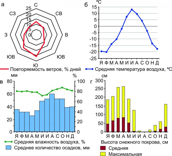
Fig. 5. Climatic characteristics of the territory of UNP Hanowei: wind frequency of certain directions, % of days (a), average air temperature, ?C (b), average humidity, %, and average amount of precipitation, mm (c) and average and maximum snow cover height, cm (d) (according to the Vorkuta Meteorological Station[12,22]) The orographic effect exerted by the ridges of the Polar Urals on the territory is very significant in relation to the winds of the eastern direction, as evidenced by their almost complete absence (Fig. 5, a). The average annual air temperature at the Khanoveysky UNP is -5.4 °C. The warmest month of the year is July, when the air warms up to an average of 13.2 ° C, and the coldest is January with an average temperature of -19.5 ° C (Fig. 5b). The amplitude of average temperatures during the year is relatively small, it is equal to 33.2 ° C, but the maximum recorded temperature amplitude of 81.8 ° C is very high. The historical maximum air temperature is 33.8 °C, the historical minimum is -48 °C. The duration of the period during which negative air temperatures can be observed here is about 313 days, the sum of negative temperatures for the year is -3219 ° C. The frost-free period in the Vorkuta region is short, its maximum length reaches 123 days, during this period the sum of air temperatures is 953?c. The growing season (average daily air temperatures above 10 ° C) lasts here up to 92 days, during which the sum of air temperatures reaches 493 ° C. The humidity in Vorkuta is about the same almost all year round. Summer is drier on average than winter: if in June-July the average humidity fluctuates around 72-74%, then in the remaining months it varies between 79-88%. The average annual humidity is 81%. The most humid air during the year is in October (88%), the driest – in June (72%) (Fig. 5, c). The annual course of precipitation is not so uniform. With an average annual amount of 507 mm/year, more than 50% of this amount falls in the period from June to October. In August, an average of 60 mm of precipitation falls, which makes it the wettest month of the year. The lowest amount of precipitation is observed in April (26 mm/month) (see Fig. 5, c). About 2/3 of the year there is a steady snow cover in the area. The establishment of snow cover begins at the very end of September (on average 1 day in September with snow cover) and then the number of days with snow actively increases: in October there are already more than 20, in November 28, in December 29. Further throughout the year, the snow cover is stable until the end of May, when under the influence of a large amount of direct solar radiation, its rapid degradation begins. If in May the average snow height is about 53 cm, then in June it is already 4, and in July there is no snow at all. The most powerful snow cover in the vicinity of Vorkuta is observed in March-April (81 and 84 cm – average height, 180 cm – maximum) (Fig. 5, d). Snow cover can be interpreted as a reliable boundary of the summer and winter seasons along with the course of air temperatures, precipitation, etc. Vegetation and soil cover of UNP Hanowei The territory of the Khanoveysky UNP belongs to the Vorkuta district of the Pre-Ural-Ural subprovincion of the European-West Siberian tundra province, located on an elevated denudation-accumulative plain. The most common in the mosaic vegetation cover of the district is a combination of grass-shrub-green-mossy tundra with flat-hummocky marshes. On soils of lighter granulometric composition and, as a consequence, facilitated drainage, there are shrub-green lichen variants of large-scale tundra. With increased soil moisture, this combination may be complicated by the appearance of grass-shrub-sphagnum tundras in complexes with pushy-sedge-sphagnum swamps. Among the tundras, pre-tundra birch-spruce woodlands and birch woodlands are also occasionally found [5,18]. The vegetation cover of the elevated convex sections of the relief was often repeatedly disturbed by fires that occurred 30-50 years ago, as a result of which rows of regenerative pyrogenic successions prevail on the slopes of the Vorkuta River valley. Due to the burning of extremely flammable grasses, shrubs and lichens[21], metamorphoses of the depths of seasonal thawing also occur and, as a result, an even greater complication of the microrelief of the landfill[10].
The research area is located in the Pechora lowland in the subzone of the southern tundra, in the Bolshezemelskaya province, in the Vorkuta district of tundra surface-gley, peat- and peat-tundra gley permafrost soils[1]. The interfluvial spaces are occupied by areas of cryogenic gleezems, and the gentle slopes are occupied by cryometamorphic soils[3,20]. The soil-geochemical catena laid down by I.N. Semenkov[20] at UNP Hanovei includes two subtypes of cryometamorphic soils – gleevate permafrost (with diagnostic horizon CRMg) and simply cryometamorphic permafrost (with diagnostic horizon CRM). The manifestation of the properties of gluing does not depend on the position of the soil area on the slope, cryometamorphic gley permafrost soils are found both on the slope itself and on its exposed part at the point of transition of the slope into the bottom of the temporary watercourse [3]. The different thickness of the peat horizon within the landfill also provides classification differences between cryozems (profile O – CR – C(g)) and peat-cryozems (profile T – CR – C(g)), gleezems (profile O – G – CG) and peat-gleezems (T – G – CG)[11]. On the soil map of the RSFSR [17] along the rivers, areas of distribution of floodplain acidic soils were distinguished. Objects and methodsObjects of research As objects of research, we selected soil sections laid on the territory of the Khanoveysky educational and scientific training ground, as well as beyond its borders. The sections were laid on characteristic sections of the relief from the dividing surface (the watershed of the Vorkuta and Lek-Vorkuta rivers) to the floodplain terraces of the Vorkuta River, on which the Hanovey polygon is located directly, up to the floodplain of the Vorkuta River. The sites for laying soil sections were selected in such a way as to characterize in as much detail as possible the diversity of soil formation conditions and, consequently, soils in the studied area. In addition to the widely distributed convex surfaces of heave mounds and interbug depressions, the work carried out characterizes locally manifested soils here on arrays of tundra spots-medallions, as well as peat bogs on powerful peat deposits near thermokarst lakes. The soils considered belong to the trunks of postlitogenic, synlitogenic and organogenic soils. Within the trunk of postlitogenic soils, the departments of cryogenic and cryometamorphic, as well as gley soils are distinguished. Synlitogenic soils include soils from the alluvial department. In the trunk of organogenic soil formation, the studied soils belong to the department of peat soils. The attribution of these soils to the listed departments was the presence of certain diagnostic horizons: in the case of cryogenic soils, these are actually cryogenic-hardened horizons with the cf sign, cryometamorphic ones have CRM cryometamorphic horizons, gley soils are characterized by the presence of a gley horizon of the soil–forming rock G, and peat soils, respectively, have powerful (more powerful than 10 cm) peat horizons T. Field methods Descriptions of the profile structure of soils and morphological properties of soil profiles were carried out in accordance with the rules of classification and diagnostics of soils of Russia[11] according to the field determinant of soils of Russia[16]. The description included a consistent presentation of information about the following properties of each of the soil horizons: color, color code on the Mansell scale, humidity (determined organoleptically), addition, structure, granulometric composition (determined organoleptically), presence, size and number of inclusions, neoplasms and plant roots, the nature of the transition, the shape of the border. If a surface or buried organogenic horizon was described (litter-peat, peat or humus), the description did not include characteristics of the structure and granulometric composition. Soil samples were selected according to genetic horizons using a knife so that the mass of each of them was approximately 200 g. Samples in a non-dried state were packed in double-layer plastic bags with a zip-lock fastener. In this form, they were delivered to the laboratory. Laboratory methodsLaboratory studies were conducted in the laboratory of the Ecological and Geochemical Center (EGC) of the Department of Geochemistry of Landscapes and Soil Geography of the Geographical Faculty of Moscow State University. The selected 42 soil samples were subjected to a sample preparation procedure, including drying in a drying cabinet at a temperature of 40 ° C and sieving through a sieve with a pore diameter of 2 mm to separate the fraction of coarse earth – particles larger than 2 mm in diameter. Further, sample preparation was carried out in an individual sequence, depending on each specific type of analysis. Soil moisture (M) was determined immediately before drying the samples in the drying cabinet. The mass of an empty foil bux, wet and dry soil samples were recorded by technical scales with an accuracy of hundredths of a g, after which the humidity was calculated using the formula below: 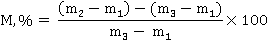
where M, % is soil moisture (%) is the amount of g of moisture in 100 g of absolutely dry soil, m 1 is the mass of an empty bux (g), m 2 is the mass of a bux with wet soil (g), m 3 is the mass of a bux with dry soil (g), 100 is the coefficient for expression the result in %. Soil acidity (pH) was determined in an introductory extract made by diluting a soil sample weighing 3 g 15 ml of distilled water (ratio 1:5). The dry soil was previously ground with a porcelain pestle in a porcelain mortar and sifted through a sieve with a pore diameter of 1 mm. pH measurements were performed on a stationary METTLER TOLEDO pH meter. The total content of easily soluble salts (TDS) was also carried out in an aqueous extract made in a ratio of 1:5. Preliminary sample preparation completely repeated the procedure for the analysis of acidity. TDS measurements (mg/L) were performed on a stationary METTLER TOLEDO TDS-EC meter. ResultsDescriptions of soil profiles
Section Kh-22-1 (fig. 6) 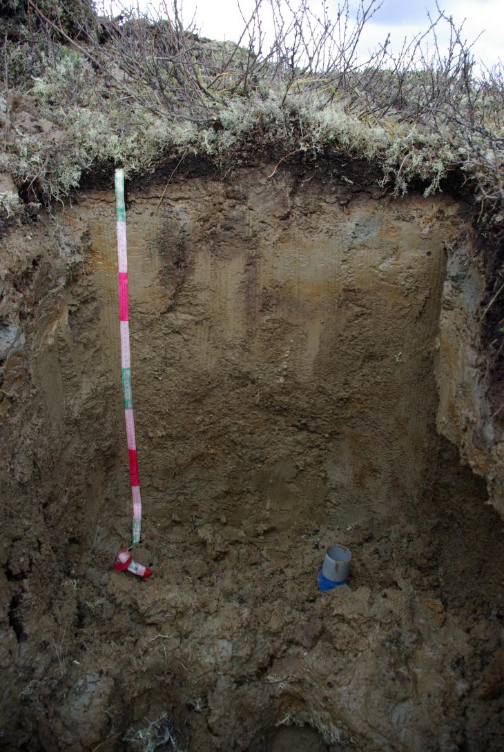
Fig. 6. Cryogenic-ozheleznenny cryogenic surface- and permafrost-peeled thixotropic The incision is laid on the convex flat-edged top of the tundra polygon, complicating the middle part of the gentle slope of the starboard side of the Vorkuta River valley. Microrelief – rare peat hummocks up to 20 cm high . Plant association: shrub-green moss-lichen tundra Description of the soil profile: O – 0-3(5) cm, dark brown, fresh, loose, low degree of decomposition of organic residues, permeated with plant roots, the transition is sharp, the border is wavy. O/G@ - 3(5)-13(34) cm, light brown with bluish-whitish spots, moist, loose, showing thixotropy properties, lingual – two large tongues, probably by frost–breaking cracks, gray tongues up to 4-7 cm wide in the upper part, the structure is unclear-lumpy, lumps up to 2 cm in size, sandy loam, permeated with plant roots, the transition is clear in color, structure and gluing, the border is wavy-lingual. Gcf@ – 13(34)-28 cm, from bluish to red, wet, slightly compacted, thixotropic, fragmentary, bluish spots with a red border, structureless, sandy loam, the transition is clear in color and humidity, the border is wavy. CG – 28-47(80) cm, brownish-gray, fresh, loose, non–thixotropic, sandy loam, structureless in the upper part, lumpy in the lower part, lumps up to 5 mm, the transition is clear in color and gluing, the border is strongly wavy. CGcf@ - 47(80)-120 cm, on a bluish-gray background large (up to 5-7 cm in diameter) red spots, wet, compacted, thixotropic, bluish spots with red interlayers, cryoturbated, structureless, sandy loam-light loamy, noticeable Fe-Mn primers up to 2 mm in diameter, the transition is sharp on the roof MMP, the border is flat. CG? – 120+ cm, similar to the overlying horizon, but frozen. Section Kh-22-2 (fig. 7) 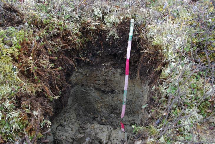
Fig. 7. Peat-gleezem cryogenically-ozheleznenny The incision is laid on the gently sloping slightly convex surface of the tundra polygon. Microrelief – frequent peat hummocks up to 40 cm high, with a diameter of up to 0.5 m. Plant association: grass-shrub-sphagnum tundra Description of the soil profile: T – 0-25 cm, a powerful peat horizon, dark brown, medium degree of decomposition of organic residues, loose, fresh, densely penetrated by roots, the transition is clear in color and inclusions, the border is slightly wavy. T’ is 25-29 cm, similar to the overlying horizon, but of a higher degree of decomposition, with gravel inclusions up to 3 mm in diameter, the transition is sharp in color, granulometric composition, inclusions, gluing, the border is wavy. G – 29-43 cm, gley horizon, bluish-gray with rusty fragments, red spots are unclear, moist, compacted, structureless, sandy loam, the transition is clear in color. [T] – 43-48 cm, buried peat lens is dark brown, high degree of decomposition, up to 5 cm wide. CG@ – 40-50 cm, darker than the overlying horizon, without manifestations of ozheleznenie, cryoturbated – the left part of the horizon is bulged 20 cm up, compared with the left, the transition is sharp on the roof of the MMP. CG – 50... cm, similar to the overlying one, but frozen, containing thin (up to 1 cm) slivers of pure ice, transparent, without signs of layering and air bubbles, the transition is not opened. Section Kh-22-3 (fig. 8) 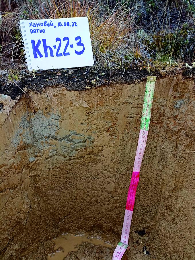
Fig. 8. Gley thixotropic cryosem The section is laid on a gentle slightly convex slope of the valley of an unnamed stream flowing into the Vorkuta River. Microrelief – flat spots-medallions separated by sphagnum-greenish rollers. Plant association: bare algal "cortical" surface of the medallion spot. Description of the soil profile
Ao – 0-1 cm, low-power crustal horizon of the surface of the soil spots-medallions, dark brown, moist, loose, decomposition of organic residues is not observed, the transition is sharp in color and composition of the horizon, the border is smooth. CRg – 1-18 cm, gley, from light brown to bright bluish, compacted, moist, thixotropic, structureless, light-medium-loamy, gradual transition in color. CR – 18-40 cm, gley horizon, light brown, compacted, wet to wet, thixotropic, structureless, light-medium loamy, the transition is not opened. At a depth of 35 cm, there is an outlet of permafrost waters. Section Kh-22-4 (fig. 9) 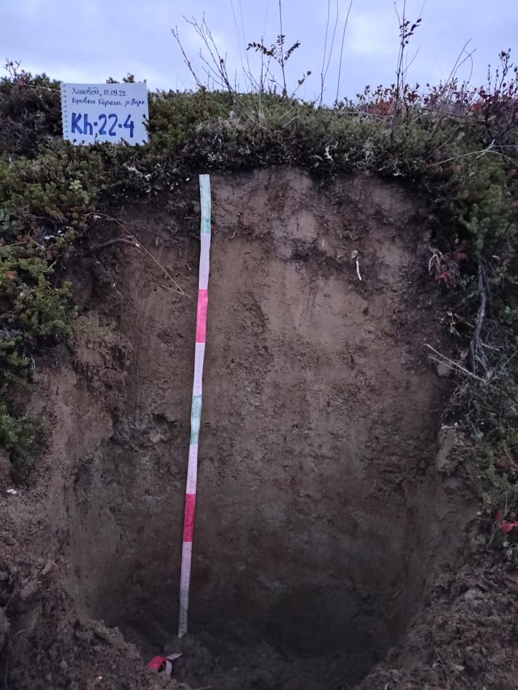
Fig. 9. Gleevaty cryozem on ancient alluvial deposits The incision is laid on the edge of the steep erosion slope of the II above-floodplain terrace of the Vorkuta river (stripping). Plant association: shrub-green moss-lichen tundra. Description of the soil profile O – 0-2(8) cm, dark brown, loose, fresh, low degree of decomposition of organic residues, densely permeated with roots, the transition is sharp in color and composition of the horizon, the border is slightly wavy. O/Cg – 2(8)-10(19) cm, gray-brown, slightly compacted, fresh, sandy loam, indistinctly lumpy, inclusions of two inclined layers of the horizon O (similar to the overlying one) 5-7 cm wide, penetrated by roots (especially in the layers O), the transition is clear in color, gluing, the absence of interlayers of O and addition, the border is smooth. Cg – 10(19)-37 cm, glued, from barely noticeable bluish to gray-brown, slightly compacted, fresh, sandy loam, the structure is unclear-lumpy, inclusions of rare boulders up to 10 cm in size, rare roots up to 7 mm in diameter, barely discernible layering, the transition is clear by the presence of layering and the degree of gluing, the border is flat. Gg - 37+ cm, gley layered, from bluish-gray to reddish-brown, dense, fresh, sandy loam-light loamy, structureless. Section Kh-22-5 (fig. 10) 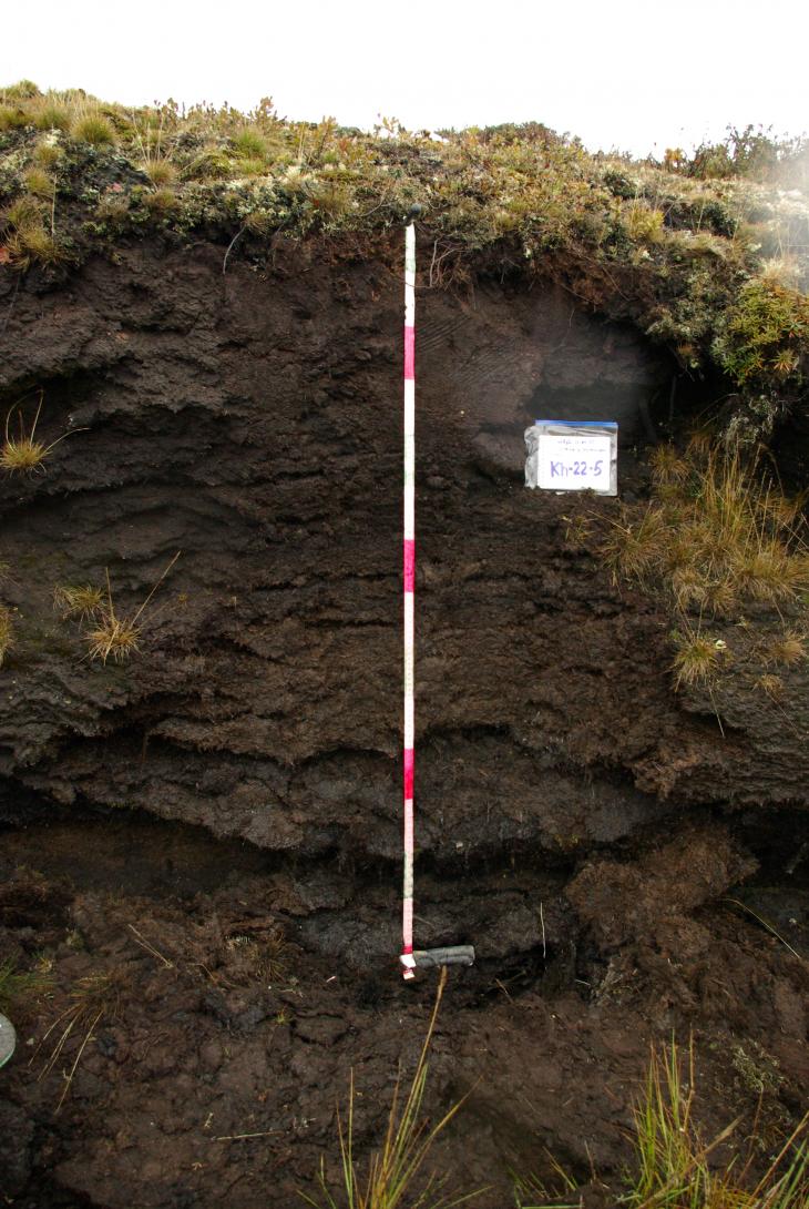
Fig. 10. Peat oligotrophic soil The cut is laid on the high abrasive shore of a thermokarst lake with a height of about 2 m. The material of the shore is peat (stripping). Plant association: shrub-green moss-lichen tundra Description of the soil profile T – 0-10 cm, peat of a low degree of decomposition, shrub-lichen, with roots of bagulnik, blueberry, shiksha, cloudberry, sheep's fescue, veinik, lichens, moss. Reddish-brown, the transition is clear, the border is wavy. T’ – 10-44 cm, peat of a high degree of decomposition, the composition is not determined, loose, moist, dark brown, the transition is gradual, the border is smooth. T’ is 44-66 cm, peat is dark brown, of a high degree of decomposition, the composition is not differentiated, loose, moist, horizontal cracks (separation lines) are visible, the transition is clear, the border is slightly wavy. T’’ is 66-100 cm, the peat is reddish–dark brown, of a high degree of decomposition, the composition is not differentiated, loose, moist, horizontal stratification is lost, the transition is clear, the border is smooth. T’’ – 100-145 cm, peat is dark brown, medium degree of decomposition, remains of wood (bark) and roots are visible, obvious signs of horizontal divisibility, separation lines, slightly compacted, wet, the transition is not opened. Section Kh-22-6 (fig. 11) 
Fig. 11. Cryometamorphic gley soil The incision is laid on a flat subhorizontal dividing surface of the pp. Vorkuta and Lek-Vorkuta. Microrelief – rare grass hummocks up to 10-15 cm high . Plant association: coarse-grained grass-shrubby green-mossy tundra. Description of the soil profile O – 0-3(7) cm, dark brown, medium degree of decomposition of organic residues, loose, fresh, penetrated by roots up to 3 mm in diameter, the transition is sharp in color and composition of the horizon, the border is wavy.
CRM – 3(7)-16 cm, yellowish-gray-brown, fresh, compacted, sandy loam-light-loamy, caviar structure, eggs up to 3 mm in diameter, the manifestation of gluing in the form of rare indistinct spots (pale blue with a red border), spot sizes 5x10 cm, rare roots up to 3 mm in diameter, the transition is gradual. C – 16+ cm, yellowish-gray-brown, unglued, fresh, dense, sandy loam-light loamy, structure similar to the overlying horizon, inclusions of pebbles up to 10 cm in size, the transition is not opened. Kh-22-7 (fig. 12) 
Fig. 12. Cryometamorphic permafrost-gleevate (in the left part of the profile) and humus-cryometamorphic surface- and permafrost-gleevate (in the right part of the profile) soil The section is laid on the convex flat-rounded top of the permafrost polygon, complicating the lower part of the gentle slope of the starboard side of the Vorkuta River valley, gradually turning into the steep slope of the II above-floodplain terrace. Microrelief – rare peat hummocks up to 20 cm high . Plant association: shrub-green moss-lichen tundra Description of the left part of the soil profile: O – 0-3 cm, reddish-dark brown, medium degree of decomposition of organic residues, abundantly permeated with the roots of Alpine arctous, shiksha, dwarf willow, dwarf willow, dwarf birch, etc. plant species, inclusions of small pebbles, the transition is sharp in color and composition of the horizon, the border is wavy. CRM – 3-55 cm, from light gray-brown to red, fresh, slightly compacted, sandy loam-light loamy, caviar structure, eggs up to 1-2 mm in diameter, rare roots up to 1 cm in diameter, the transition is clear due to the absence of oglenii, the border is wavy. C – 55-70 (72) cm, light gray-brown, fresh, compacted, sandy loam-light loamy, finely lumpy, signs of horizontal divisibility are observed in the lower part, single roots with a diameter of up to 0.5 cm, the transition is clear by the presence of gluing and layering, the border is slightly wavy. CG – 70(72) ... cm, from light gray-brown to bluish and red, moist, compacted, light-medium loamy, structureless, layered, loose dark brown iron-manganese nodules, the transition is not opened. Description of the right part of the soil profile: H– 0-11 cm, dark brown, medium degree of decomposition of organic residues, abundantly permeated with the roots of alpine arctous, shiksha, dwarf willow, dwarf willow, dwarf birch, etc. types of plants, valzhny, curd, smearing, the transition is sharp in color and composition of the horizon, the border is wavy. Cgf – 11-18 cm, from light gray-brown to red, fresh, slightly compacted, sandy loam-light loamy, gley spots (glaucous inside, red at the edges), subhorizontal oriented, rare roots with a diameter of up to 1 cm, the transition is clear due to the absence of gluing, the border is wavy. C – 18-70 (72) cm, light gray-brown, fresh, compacted, sandy loam-light loamy, finely lumpy, signs of horizontal divisibility are observed in the lower part, single roots with a diameter of up to 0.5 cm, the transition is clear by the presence of gluing and layering, the border is slightly wavy. CGf – 70(72) ... cm, from light gray-brown to bluish and red, moist, compacted, light-medium loamy, structureless, layered, loose dark brown iron-manganese nodules, the transition is not opened. Section Kh-22-8 (fig. 13) 
Fig. 13. Peat-gleezem oxylated-gleevy permafrost The incision is laid on the convex flat-edged top of the tundra polygon, complicating the middle part of the gentle slope of the starboard side of the Vorkuta River valley. Microrelief – frequent peat hummocks up to 40 cm high . Plant association: grass-shrub-sphagnum tundra (with an abundance of marsh marsh) Description of the soil profile T – 0-11 cm, sphagnum peat, low degree of decomposition, brown, penetrated by roots up to 3 mm in diameter, gradual transition. T’ – 11-21(23) cm, peat, similar to the overlying horizon, but more strongly decomposed, more roots than in the overlying one, the transition is sharp, the border is smooth. T’ – 21(23)-31 cm, peat is dark brown-red, medium degree of decomposition, rare roots, the transition is clear in color and degree of decomposition of organic matter, the border is smooth. Gox – 31-45 cm, gley, from light brown in the upper part to gray-gray in the lower, moist, dense, light-medium loamy, manifestation of ozheleznenie along the root canals (vertically oriented), rare roots with a diameter of up to 1 mm, the transition is sharp along the border of the MMP, the border is smooth. CG – 45... cm, similar to the overlying horizon, but without roots, frozen, high-ice (volume ice content ? 20%), subhorizontal oblique slits of transparent ice without layering and air bubbles up to 3 cm in diameter, the transition is not opened.
Section Kh-22-9 (fig. 14) 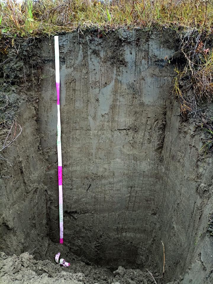
Fig. 14. Alluvial humus soil The cut is laid on the edge of the steep slope of the I above-floodplain terrace of the Vorkuta river (stripping). Plant association: grass-grass-green moss Description of the soil profile AY – 0-20 cm, gray humus horizon of alluvial soils, dark gray, without undecayed organic residues, fresh, loose, finely lumpy-nutty, finely sandy silted, rare and thin roots up to 1 mm in diameter, gradual transition. C - 20 cm, from light gray-yellow to dark gray, the layers are unclear, rarely wider than 3 mm, moist, loose, finely lumpy, finely sanded silted, inclusions of rare pebbles up to 7 cm in size, the transition is not opened. Section Kh-22-10 (fig. 15) 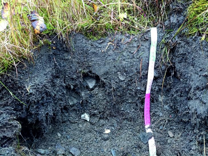
Fig. 15. Gray-humus coarse-humus soil on boulder-pebble alluvium The cut is laid on the low floodplain of the Vorkuta River, which forms a ledge about 20 cm high above the water's edge in this place.Plant association: grass-grass Description of the soil profile AO – 0-12 cm, dark gray-brown, low degree of decomposition of organic residues, lumpy, finely-medium-sanded silted, inclusions of weakly-rounded fine gravel and crushed stone up to 5 mm in diameter, single large roots up to 1 cm in diameter and frequent thin ones up to 2 mm in diameter, the transition is sharp in structure, granulometric composition and the presence of large boulders. R – 12+ cm, coarse-pebbled, fine-grained content of about 50%, dark gray, moist, compacted, fine–grained - coarse- and medium-sanded. Classification and diagnostics of soils Most of the soils studied within the UNP Khanovei have several basic common features of the morphological structure of the profile. First of all, this is a manifestation of gluing, which indicates waterlogging of soils due to the large amount of incoming precipitation and the barrier function of permafrost rocks. Also, for example, in the case of gleevate thixotropic cryozem (Fig. 16, c), increased humidity and, in this regard, traces of gluing can develop due to active melting of MMP (especially in areas with sparse vegetation cover or deprived of it altogether), which leads to the formation of entire horizons of permafrost waters. 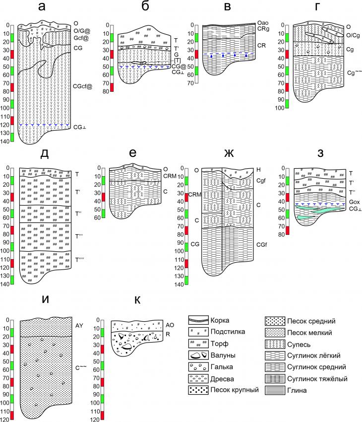 Fig. 16. Profile structure of soils studied at UNP Hanovei: cryogenic-ozhelezennyy surface- and permafrost-gley thixotropic cryozem (a), peat-gley cryogenic-ozhelezennyy (b), cryozem gley thixotropic (c), cryozem gley on ancient alluvial deposits (d), peat oligotrophic soil (e), cryometamorphic gleevate soil (e), cryometamorphic permafrost-gleevate and humus-cryometamorphic surface- and permafrost-gleevate (g), peat-gleezem oxidized-gleev permafrost (h), alluvial humus soil (i), gray humus coarse-humus soil on boulder-pebble alluvium (k) Gluing is manifested here to varying degrees, but it is especially noticeable in soils characterized by a combination of high humidity, heavy granulometric composition, as well as close to the surface of the upper boundary of the MMP. An example of such a combination is peat–gleezem oxidized-gley permafrost (fig. 16, h). In sections of cryozem (fig. 16, a) and humus-cryometamorphic soil (Fig. 16, g), there is even a so-called double-gley profile. In terms of classification, this is expressed in the introduction to the name of the subtypes of the surface- and super-permafrost–gley and -gley. In this situation, there is a median non-adhesive horizon between two soil horizons showing signs of gluing. Also, a fairly common property of soils at the Khanoveysky landfill is thixotropy, that is, the ability to liquefy with prolonged mechanical action. When diagnosing the studied sections, the property of thixotropy in some cases manifested itself so vividly that it became the reason for the introduction of the subtype "thixotropic" in the name of the soil, as, for example, in the case of cryosystems (Fig. 16, a, b). These soils are characterized by a combination of high humidity with a heavy (mainly loamy) granulometric composition, the sands are thixotropic to a much lesser extent, so the cryosem gleevat on ancient alluvial deposits (Fig. 16, d) is not thixotropic due to the fact that a lighter granulometric composition does not create water-saturated horizons in its profile. The process of cryometamorphization, expressed in the formation of a CRM horizon with a peculiar caviar structure, mainly affects the soils of autonomous relief positions, where humidity is not so high, while the granulometric composition of the soils is sandy loam-loamy. The department of cryometamorphic soils includes, for example, the profile of cryometamorphic gleevate soil on the watershed surface (Fig. 16,e) or a combination of cryometamorphic and peat-cryometamorphic on the convex surface of the polygon, smoothly turning into the edge of the slope of the II above-floodplain terrace of the Vorkuta river (Fig. 16, g).
The presence of the MMP horizon in the soil profile is not so often expressed in the name: often soils belonging to the cryogenic (cryozems) department do not require the inclusion of the word "permafrost" in the name, since cryogenesis as the leading process of soil formation itself implies this. Cryotextures of the encountered permafrost horizons of soils are mainly of two types – massive (evenly distributed ground mass in ice) (Fig. 16, a) and schlier (interlayer of frozen soil and lenticular layers – schliers, - pure transparent ice) (Fig. 16, b,z). A special position among the soils studied at the landfill is the peat oligotrophic soil belonging to the peat soils department, uncovered in the outcrop of the high shore of the thermokarst lake (Fig. 16, d) and soils whose sections were laid hypsometrically below the edge of the II above-floodplain terrace of the Vorkuta River. This is a section of alluvial humus soil (Fig. 16, and) and gray humus coarse-humus soil on a boulder-pebble alluvium. The warming effect of the river flow on the banks leads to the fact that the MMP horizon does not occur in the profiles of these soils, and cryogenic processes (structuring, cryoturbation, etc.) do not manifest themselves. Also, a significant difference between these soils from those located on the gently sloping surface of the I terrace is a significant simplification of the granulometric composition to sandy and larger. Soil propertiesThe moisture content of the soils described and tested on the territory of the Khanoveysky UNP varies quite widely – from 1.7 to 899.8% (Fig. 17, a-k). On average, it is 146%, while most often the soil moisture varies within 400%, only in some cases exceeding this indicator. As a rule, increased humidity is characteristic of organogenic horizons or horizons of heavy granulometric composition (sandy loam and loamy), which, due to the large total volume of the pore space, can contain moisture several times more than its own mass. Low humidity is mainly typical for soils of light granulometric composition (sandy and larger). 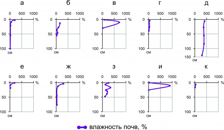
Fig. 17. Profile distributions of soil moisture values (%): cryogenic-ozhelezenny cryogenic- and permafrost-gley thixotropic cryozem (a), peat-gley cryogenic-ozhelezenny (b), cryozem gley thixotropic (c), cryozem gley on ancient alluvial deposits (d), peat oligotrophic soil (e), cryometamorphic gleevate soil (e), cryometamorphic permafrost-gleevate and humus-cryometamorphic surface- and permafrost-gleevate (g), peat-gleezem oxidized-gleev permafrost (h), alluvial humus soil (i), gray humus coarse-humus soil on boulder-pebble alluvium (k) It is interesting to note that for the soils considered, it is possible to assign to one of three types of profile moisture distribution. The first type of distribution – close to monotonous (with the possibility of allocating the maximum humidity in the upper part of the profile corresponding to the surface organogenic horizon O or T) - includes the soil profiles in Fig. 17, a, d, d, e, f, K. The second type of distribution – tortuous, - includes the soil profile in Fig.. 17, p. In the upper part of the section of this soil, there is an alternation of peat horizons of various capacities and degrees of decomposition, as a result of which moisture accumulates unevenly in them. It is worth noting that despite the presence of a horizon of high-acidic MMPs in the lower part of the profile (Fig. 17z), the humidity of the upper moisture-saturated horizons T still exceeds the humidity of the lower CG? by about 2-3 times. The third type of profile distribution is median–accumulative, which includes two soils - Fig. 17, b, and. In the case of the first of them, the increased (almost 11 times in relation to the above and below soil horizons) humidity, reaching 707% here, can be associated with practically no organogenic horizon, and with a light-medium-loamy granulometric composition. In the case of the second soil, which has mainly fine-grained granulometric composition, high humidity (899.8%) may be due to the high moisture capacity of the organic part of the AY horizon. The studied soils belong to the gradations from acidic to close to neutral. The pH values are distributed extremely unevenly in the soil profiles, and their variation occurs in the range from 4.7 to 7.5 units. In almost all cases, in the profile distribution of soil pH values, a pattern is observed in which the most acidic (low pH values between 4.5 and 5.5) horizons are surface organogenic, and with the depth of the profile, the acidity decreases (pH increases to about 6-7 units (Fig. 18). 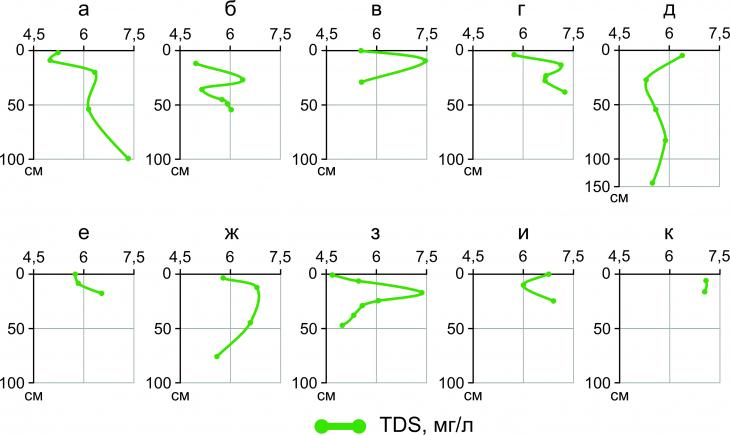
Fig. 18. Profile distributions of pH values: cryogenic-ozhelezenny cryogenic-surface- and permafrost-gley thixotropic cryozem (a), peat-gley cryogenic-ozhelezenny (b), cryozem gley thixotropic (c), cryozem gley on ancient alluvial deposits (d), peat oligotrophic soil (e), cryometamorphic gley soil (e), cryometamorphic permafrost-gleevate and humus-cryometamorphic surface- and permafrost-gleevate (g), peat-gleezem oxidized-gleev permafrost (h), alluvial humus soil (i), gray humus coarse-humus soil on boulder-pebble alluvium (k) The reason for this, most likely, is the high content of organic matter in the upper horizons, which, when decomposed, releases a large amount of weak organic acids, which are a source of acidification of soil extracts. Below, there is a transition to the mineral part of soils containing small amounts of organic matter and, as a result, depleted by H+ cations. Taking into account the generally low power of the O and T horizons, for example, in the cases shown in Fig. 18, a, b, d, e, f, the contrasts of the distribution of pH values can be very sharp. The total content of easily soluble salts (LRS) by the nature of profile distributions can also be divided into types: relatively monotonous with possible surface accumulation of salts (Fig. 19, a, g, d, e, f, k), tortuous (Fig. 19, b, h) and with pronounced surface accumulation of salts (fig.fig. 19, b, and). 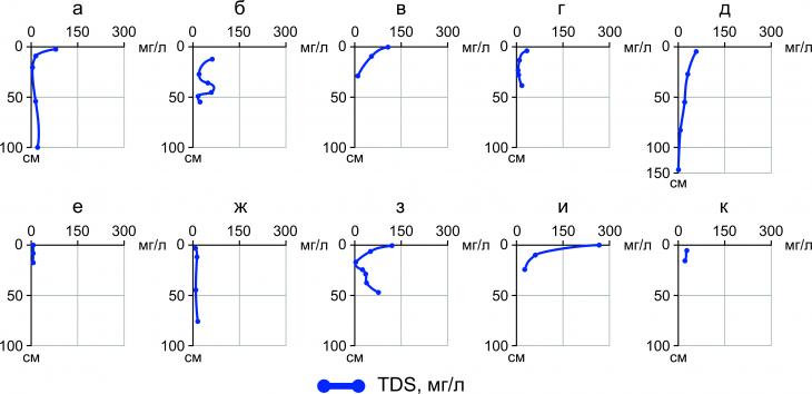
Fig. 19. Profile distributions of the values of the total content of easily soluble salts (TDS, mg/l): cryogenic-ozhelezennyy cryogenic-ozhelezennyy surface- and permafrost-gleevy thixotropic (a), peat-gleezem cryogenic-ozhelezennyy (b), cryozem gleevy thixotropic (c), cryozem gleevy on ancient alluvial deposits (d), peat oligotrophic soil (e), cryometamorphic gleevy soil (e), cryometamorphic permafrost -gleevataya and humus-cryometamorphic surface and permafrost-gleevate (g), peat-gleezem oxidized-gleev permafrost (h), alluvial humus soil (i), gray humus coarse-humus soil on boulder-pebble alluvium (k) The fact that easily soluble salts accumulate mainly in the surface organogenic horizons indicates the aerogenic path of their entry into local landscapes. The washing water regime of soils explains the monotonous distribution of a relatively low amount of salts (about 10-20 mg/l) in the mineral part of soil horizons. A special case of the profile distribution of LRS in the soil profile is the increase (almost from 0 to 100 mg/l) of the TDS value in the profile of a soil with a high-acid horizon in the profile (Fig. 19, h). Presumably, this is due to the manifestation of a permafrost and permafrost geochemical barrier, as a result of which moisture with a high salt content cannot be washed out of the profile below the MMP boundary. Discussion Peat- and peat-tundra gley permafrost soils are most widespread within the Vorkuta soil district. The total area of their habitats occupies 4.5% of the area of the entire Komi Republic. Along with the zonal type of soils – tundra surface-gley (including podzol), they are widely distributed in automorphic landscape conditions. They are confined to the convex surfaces of riverine and watershed ridges, brow slopes, composed of loamy soil-forming rocks. Most often, these types of soils are found as dominant in the composition of soil cover complexes with dry peat analogues (tubercles) and spot soils. It is the bumpy-spotted microrelief, complicating the flat dividing surfaces composed of heavy rocks, that has the main effect on the micro-heterogeneity of the soil cover[1]. Also, the separable surfaces are complicated by erosive incisions created by the developing gully-beam network, especially intense in recent years, which is characterized by active thermal erosion due to the melting of the MMP. The catchments of gullies and ravines, as separate elements of the landscape, have a specific soil cover. Its structure is represented by a combination of permafrost gleezems (autonomous interfluvial elementary geochemical landscape) with cryometamorphic typical and gleevate soils (transeluvial slope landscapes)[3, 20]. Cryometamorphic soils were also found in the area of the village of Yeletsky, where they occupied autonomous positions of the relief of the river valley. Mustache, and lower down the slope (catena from the dividing surface of the interfluve pp. Usa and Yelets to the Yelets convex-bumpy peat bog) combine cryozems and peat-cryozems permafrost with peat-gleezems[4]. In general, in the soils considered in [4], there is approximately the same pattern of the profile distribution of acidity as in the ones we studied at the Khanoveysky UNP. Surface and near–surface horizons, most affected by biogenic processes of soil formation, have an acidic and slightly acidic reaction (pH = 3.9–5.6), and with depth the pH values increase to about 6.3-6.9 (the reaction of the medium becomes close to neutral). Distribution of electrical conductivity values (EC, µs/cm) in soil profiles (EC:TDS approximately 1:2) also largely repeats the basic pattern observed in the soil sections studied by us – the most mineralized is the surface organogenic horizon (on average from 30 to 60 mg LRS per 1 liter), after which the content of easily soluble salts drops by 4-6 times. Compared with the Khanoveysky landfill, the soils near the Yelets peat bog are not so strongly mineralized in the upper part of the profile (the maximum measured LRS content is 116 mg/l, unlike the surface horizons at the UNP Khanovey, where the maximum salt content is around 280 mg/l)[4]. The pH values of soils studied within a catchment area of about 0.25 km2 [3] also correspond to the reaction of the medium from acidic (3-4.5) to slightly acidic (4.5–6.5). Moreover, the breadth of variation of pH values within the framework of the soil-geochemical catena is considered: if in the autonomous positions of the soil relief there are very monotonous profile pH distributions (values about 3-3.5 units), then in the transit positions of the catena slopes the variation interval becomes much wider, the upper pH limit reaches 6.4–6.5 units[3.20]. Anthropogenic soil formation within the city of Vorkuta, where before the start of intensive development and the organization of functional zoning, the soil cover was similar to the natural undisturbed, led to a noticeable increase in pH values. Vorkuta soils have a pH of 6.6 to 8.3 units, which corresponds to a medium already close to neutral and slightly alkaline[9]. Core samples of permafrost soils taken from a deep drilling well were examined for their moisture content. At depths of 1.1–1.3 and 1.3–1.5 m, the natural soil moisture was estimated at 125.18 and 125.82%, respectively. The humidity at the yield boundary was 37.8 and 32.4%, and at the rolling boundary – 28.3 and 24.9%, respectively[3]. The high humidity of the frozen soils of the studied landfill is due to their high iciness. Core samples at depths of 1.3–3.0 m include numerous layers of thin (up to 2 mm) ice slots and veins of white transparent ice (7-9 mm), occasionally there are layers of coarse-crystalline pure transparent ice[3]. Conclusion The authors studied the soils at the Khanovey educational and scientific training ground and beyond. Morphological features of soil profiles were considered, as well as their physical and physico-chemical properties – humidity, acidity, content of easily soluble salts.
The structure of the soil cover is dominated by soils whose genetic profile is mainly formed by various cryogenic processes – cryometamorphization (cryometamorphic soils), cryogenesis (cryogenic soils – cryosystems). It also includes combinations of peat-gley soils (peat-gleezems) with a relatively low capacity of the peat horizon and peat oligotrophic soils on dry peat bogs, the peat capacity in which reaches several meters. Sometimes micro-heterogeneities of cryogenic relief (combinations of hummocks with depressions around them, tundra soils-spots with moss-lichen rollers, etc.) create a very contrasting soil cover on a small area. Sometimes the differences created by the microrelief are sufficient to have a classification value. So, for example, one section, revealing the profiles of soils under a hillock and a depression, at a distance of less than 1 m from each other, cryometamorphic permafrost-gleevate and humus-cryometamorphic surface- and permafrost-gleevate soils are replaced. The soils considered have three main types of profile moisture distribution: close to monotonous, tortuous and medium-accumulative. Soil moisture varies from 2 to almost 900%. As a rule, surface organogenic horizons are characterized by increased humidity. Especially hygroscopic peat and peat. The hydrogen index of soil acidity (pH) varies in the profiles considered by us from 4.5 to 7.5 units, which corresponds to gradations from acidic to close to neutral reactions of the medium. The pH distribution in soil profiles is most often characterized by a minimum value (the most acidic reaction of the medium) in the surface organogenic horizon (pH = 4.5–5.5), and when switching to the mineral part of the profile, the pH increases to 6.5–7.5. The soils under consideration contain from almost 0 to 300 mg/l of easily soluble salts. The surface horizons are also characterized by an increased salt content, and with the depth of the concentration of LRS, they almost inevitably decrease. This distribution indicates the aerogenic introduction of salts into soils (with atmospheric precipitation), as well as the ability of salts to accumulate in the surface horizons of soils without penetrating deep into the profiles. The results of this study obtained by the authors are among the few data on the soils of the south-east of the Bolshezemelskaya tundra in the Vorkuta region and their properties. In many respects, they are confirmed by the previously obtained information about the catenary structure of the soil cover and the properties of soils of a similar natural environment in the area of the village of Yeletsky (located about 100 km east of UNP Hanovei), partly by the results of small soil–geochemical studies at the landfill itself. The studied soil diversity clarifies the researchers' understanding of the structure of the soil cover of the territory. Nevertheless, in many respects the presented results are preliminary. Thus, the final versions of the classification names of soils remain in question, which in some cases proved difficult to give unambiguously. Also, for further research of soil properties, it is necessary to expand the range of chemical analytical work, the results of some of which, among other things, will be able to clarify the results of classification and diagnostics of soils. ThanksThe authors express their gratitude to Professor M.I. Gerasimova for her help in classifying soils. The authors are also grateful to S.N. S. V.S. Isaev and Head of the laboratory D.O. Sergeev for their assistance in organizing field work and transporting samples.
References
1. Soil Atlas of the Komi Republic. (2010). Ed. G.V. Dobrovolsky, A.I. Taskaeva, I.V. Downhole. Syktyvkar: Komi Republican Printing House LLC. 356 p. + maps.
2. Baulin V.V., Chekhovsky A.L., Sukhodolsky S.E. (1981). The main stages in the development of permafrost in the north-east of the European part of the USSR and Western Siberia. History of the development of permafrost in Eurasia. – Moscow: Science. P. 41–60.
3. Budantseva N.A., Gorshkov E.I., Isaev V.S., Semenkov I.N., Usov A.N., Chizhova Ju.N., Vasil'chuk Yu.K. (2015). Engineering geological and geochemistry features of the palsa and lithalsa landscape in the area of educational and scientific polygon Khanovey. Engineering Geology. N3. P. 34–50.
4. Vasilchuk Yu.K., Vasilchuk J.Yu., Belik A.D., Ginzburg A.P., Budantseva N.A., Vasilchuk A.C. (2020). Cryogenic soils near the Eletsky village, north-east of the Komi Republic. Arctic and Antarctic. №4. P. 51–79. doi: 10.7256/2453-8922.2020.4.34011.
5. Geobotanical zoning of the Non-Chernozem region of the European part of the RSFSR (1989). – Leningrad: Science. 64 p.
6. Geocryology of the USSR. European territory of the USSR (1988). Ed. E.D. Ershov. – Moscow: Nedra. 358 p.
7. Geological and geomorphological maps (1964). / B.I. Guslitser, V.A. Raznitsyn, M.V. Fishman, G.A. Chernov. Atlas of the Komi ASSR. – Moscow: P. 9–18.
8. Devyatova E.I. (1963). On the marginal formations of the Valdai Glacier on the territory of the Arkhangelsk Region . Proceedings of the commission for the study of the Quaternary period, vol. 21. - Moscow: Publishing House of the Academy of Sciences of the USSR. P. 5–15.
9. Dymov A.A., Kaverin D.A., Gabov D.N. (2013). Properties of soils and soil-like bodies in the city of Vorkuta . Eurasian Soil Sci. No. 2. P. 240–248.
10. Isaev V.S., Bezdelova A.P., Sergeev D.O. (2021). Integrated landscape monitoring of permafrost in the southern tundra (on the example of the Khanovei test site) . Proceedings of the international conference "Cryosphere Transformation & Geotechnical Safety '21 Salekhard, Yamal, Russia" (November 8–12, 2021. Salekhard, Russia). P. 173–176.
11. Classification and diagnostics of Russian soils (2004). – Smolensk: Oikumena. 342 p.
12. Climate of Vorkuta: http:. www.pogodaiklimat.ru/climate/23226.htm (accessed 10/13/2022).
13. Forests of the Komi Republic (1999). / G.M. Kobuzov, A.I. Taskaev, S.V. Degteva and others - Moscow: Design. Information. Cartography. 332 p.
14. National Soil Atlas of Russia (2011). Ed.: A.S. Shoba / Moscow State University. Faculty of Soil Science. Astrel. 632 p.
15. Oberman N.G. (1981). The history of the formation of permafrost in the zone of the Timano-Ural region. In History of the development of permafrost of Eurasia. – Moscow: Nauka. pp. 60–73.
16. Field determinant of soils. (2008). – M.: Soil in-t im. V.V. Dokuchaev. 182 p.
17. Soil map of the RSFSR on a scale of 1:2,500,000 (1988). / All-Union Academy of Agricultural Sciences. IN AND. Lenin; Soil Institute. V.V. Dokuchaev. Head. ed. V.M. Friedland . GOSAGROPROM,
18. Vegetation of the European part of the USSR. (1980). Ed. S.A. Gribova, T.I. Isachenko, E.M. Lavrenko. – Leningrad. Nauka, 429 p.
19. Severyanova E.N. (2015). The content of heavy metals in soils and plants in the vicinity of a coal mining enterprise on the example of the Vorkutinskaya mine in the city of Vorkuta, Komi Republic . Bulletin of the Bashkir University. Vol. №3. P. 881–888.
20. Semenkov I.N. (2016). Forms of finding metals in loamy tundra, taiga, subtaiga and forest-steppe soil-geochemical catenas / Abstract of the dissertation for the degree of Candidate of Geographical Sciences. – Moscow: 24 p.
21. Snytkin G.V. (2001). Features of forest fires in different formations, forest types and methods of their extinguishing in the forests of the extreme north-east of Siberia. Forest Bulletin, No. 5. P. 37–48.
22. Reference book on the climate of the USSR. Issue 1. Arkhangelsk and Vologda regions, Karelian and Komi ASSR. Part II. Air and soil temperature. (1965). – Leningrad: Gidrometizdat. 359 p.
23. Fishman M.V., Pystin A.M. (2001). Geological structure. Atlas of the Komi Republic. – Moscow: Design. Information. Cartography. pp. 26–27.
24. Chernov A.A. (1953). Geological structure . Productive forces of the Komi ASSR. T. 1. Geological structure and minerals. – Moscow: Publishing House of the Academy of Sciences of the USSR. P. 34–256.
25. Isaev V., Arata K., Kotov P., Sergeev D., Uvarova A., Koshurnikov A., Komarov O. Multi-Parameter Protocol for Geocryological Test Site: A Case Study Applied for the European North of Russia . Energies. 2022. Vol. 15. №6. 2076. https:. doi.org/10.3390/en15062076
26. Kotov P.I., Isaev V.S., Ospennikov E.N., Scibilia E.P. (2022). The Forecast of the Temperature Regime of a Northern Railway Embankment in Tundra Near Hanovey Station. Moscow University Geology Bulletin. Vol. 77. №3. P. 295–304.
27. Rossi M., Dal Cin M., Picotti S., Gei D., Isaev V.S., Pogorelov A.V., Gorshkov E.I., Sergeev D.O., Kotov P.I., Giorgi M., Rainone M.L. (2022). Active layer and permafrost investigations using geophysical and geocryological methods – a case study of the Khanovey, near Vorkuta, in the NE European Russian Arctic. Frontiers in Earth Science. Vol. 10. 22 p. https:. doi.org/10.3389/feart.2022.910078
28. Oberman N.G., Mazhitova G.G. (2001). Permafrost dynamics in the Northeast European Russia based on the period of climatic warming 1970–1975. Norsk Geografosk Tidsskrift – Norwegian Journal of Geography, Vol. 55. №4. P. 241–244. doi: 10.1080/00291950152746595.
29. Tananaev N., Isaev V., Sergeev D., Kotov P., Komarov O. (2021). Hydrological Connectivity in a Permafrost Tundra Landscape near Vorkuta, North-European Arctic Russia . Hydrology. №8(3). 106. https: doi.org/10.3390/hydrology8030106.
Peer Review
Peer reviewers' evaluations remain confidential and are not disclosed to the public. Only external reviews, authorized for publication by the article's author(s), are made public. Typically, these final reviews are conducted after the manuscript's revision. Adhering to our double-blind review policy, the reviewer's identity is kept confidential.
The list of publisher reviewers can be found here.
The subject of the research was the soils of the Khanoveysky landfill of the Komi Republic.The morphological features of soil profiles, as well as their physical and physico-chemical properties – humidity, acidity, and the content of easily soluble salts were considered. Soil sections laid on the territory of the Khanoveysky educational and scientific ground, as well as outside it, were selected as objects of research. The sections were laid on characteristic sections of the relief from the watershed surface (the watershed of the Vorkuta and Lek-Vorkuta rivers) to the floodplain terraces of the Vorkuta River, on which the Khanovey landfill is located directly, up to the floodplain of the Vorkuta River. The relevance of the research is determined by the need for a detailed study of the profile structure and properties of soils, as well as soil-geochemical catenae for further use of these data in the study of radial and lateral migration flows of chemicals on the territory of the Khanoveysky landfill. A comprehensive study of the landscape structure and its features will be able to help researchers clarify their ideas about the history, agents and factors of the development of the relief of this territory, which are a controversial issue in the Russian geocryological community. In addition, the studied soil properties in detail are able to correct the construction of future landscape maps used in the organization of long-term monitoring points of the ecosystem. Descriptions of the profile structure of soils and morphological properties of soil profiles were performed in accordance with the rules of classification and diagnostics of soils of Russia according to the field soil determinant of Russia. The description included a consistent presentation of information about the properties of each of the soil horizons: color, color code on the Mansell scale, humidity (determined organoleptically), addition, structure, granulometric composition (determined organoleptically), presence, size and number of inclusions, neoplasms and plant roots, the nature of the transition, the shape of the border. If a surface or buried organogenic horizon was described (litter-peat, peat or humus), the description did not include characteristics of the structure and granulometric composition. Soil samples were selected according to genetic horizons using a knife in such a way that the mass of each of them was approximately 200 g. Samples in a non-dried state were packed in double-layer plastic bags with a zip-lock closure. They were delivered to the laboratory in this form. Laboratory studies were conducted in the laboratory of the Ecological and Geochemical Center (EGC) of the Department of Geochemistry of Landscapes and Soil Geography of the Geographical Faculty of Moscow State University. The selected 42 soil samples were subjected to a sample preparation procedure, including drying in a drying cabinet at a temperature of 40 ° C and sieving through a sieve with a pore diameter of 2 mm to separate a fraction of particles larger than 2 mm in diameter. Further, the sample preparation was carried out in an individual sequence, depending on each specific type of analysis. The reliability of the results obtained is confirmed by the proven methodology of field and laboratory studies. The results obtained by the authors are one of the few data on the soils of the south-east of the Bolshezemelskaya tundra in the Vorkuta region and their properties. In many ways, they are confirmed by previously obtained information about the catenary structure of the soil cover and the properties of soils of a similar natural environment in the area of the village of Yeletsky (located about 100 km east of UNP Khanovey), partly by the results of small soil and geochemical studies at the landfill itself. The studied soil diversity clarifies the researchers' understanding of the structure of the soil cover of the territory. The style and structure of the article meet the requirements of the journal for the publication of scientific papers. Graphic materials are acceptable. the list of references is adequate. references to literary sources are present in the text. As comments, it is possible to point out the excessive detail of the results, which complicates the semantic perception of the article. The most characteristic examples should have been chosen. In general, the article meets the requirements of scientific publications and will be of interest to the scientific geocryological community.
Link to this article
You can simply select and copy link from below text field.
|