|
MAIN PAGE
> Back to contents
Arctic and Antarctica
Reference:
Chekmareva D.P., Lobchenko E.E., Romanyuk O.L., Pervysheva O.A., Fedotova O.L.
Assessment of the impact of the formation of water resources and the quality of surface waters of the Lena River basin
// Arctic and Antarctica.
2023. № 2.
P. 88-101.
DOI: 10.7256/2453-8922.2023.2.40906 EDN: HGACAL URL: https://en.nbpublish.com/library_read_article.php?id=40906
Assessment of the impact of the formation of water resources and the quality of surface waters of the Lena River basin
Chekmareva Diana Petrovna
ORCID: 0000-0003-2327-5085
Junior Researcher, FGBI Hydrochemical Institute
344090, Russia, Rostov region, Rostov-On-Don station, 198 Stachki Ave.

|
zeikan-diana@mail.ru
|
|
 |
Lobchenko Evgeniya Efimovna
ORCID: 0000-0003-2728-4974
PhD in Chemistry
Leading Researcher, FGBI Hydrochemical Institute
344090, Russia, Rostov region, Rostov-On-Don, 198 Stachki Ave.
|
|
zeikan-diana@mail.ru
|
|
|
Romanyuk Oksana L'vovna
ORCID: 0000-0003-1864-5045
PhD in Geography
Leading Researcher, FGBI Hydrochemical Institute
344090, Russia, Rostov region, Rostov-On-Don, Stachki Ave., 198
|
|
rol_78@mail.ru
|
|
|
Pervysheva Ol'ga Aleksandrovna
ORCID: 0009-0005-0724-8652
Senior Researcher, FGBI Hydrochemical Institute
344090, Russia, Rostov region, Rostov-On-Don, 198 Stachki Ave.
|
|
poa19544@mail.ru
|
|
|
|
Fedotova Ol'ga Leonidovna
ORCID: 0009-0001-8615-7361
Junior Researcher, FGBI Hydrochemical Institute
344090, Russia, Rostov region, Rostov-On-Don, Stachki Ave., 198
|
|
ofedotova_81@mail.ru
|
|
|
|
DOI: 10.7256/2453-8922.2023.2.40906
EDN: HGACAL
Received:
02-06-2023
Published:
27-06-2023
Abstract:
Ongoing active development of natural resources, changing climatic conditions (including permafrost melting) In Eastern Siberia, it is necessary to control changes in the ecological state of the environment, one of which is surface water. The Roshydromet system has established and successfully operates a network of regime observations of the state and pollution of surface waters of the Russian Federation, ensuring the unity of measurement of the content of major pollutants in water according to uniform methods certified in accordance with the requirements of regulatory documents of the Russian Federation and international standards. In this paper, the formation of the quality of the surface waters of the Lena River basin under conditions of non–stationary climatic processes on the one hand and the anthropogenic component on the other is considered. Based on the analysis of statistically processed long–term data (2011-2021) obtained by the state monitoring network of Roshydromet, an assessment of the water quality of the Lena River and its major tributaries - the Vitim, Olekma, Aldan, Vilyu rivers is given. The spatio-temporal distribution of characteristic pollutants in the water of the rivers of the basin has been studied: organic substances (according to BPK5 and COD), phenols, petroleum products, iron, copper and zinc compounds. It was found that in the conditions of the Arctic climate, the seasonal distribution of organic substances in surface waters was insignificant. The presence of heavy metal compounds in the water of the Lena River basin water bodies is mainly due to anthropogenic sources of pollution. In the long-term plan, the water of the rivers of the Lena River basin was assessed as the 3rd satisfactory quality class.
Keywords:
chemical composition of water, surface water quality, pollutants, Lena River basin, tributaries of the Lena River, Republic of Sakha, water pollution, long-term trend, dynamics of concentrations, water quality assessment
This article is automatically translated.
You can find original text of the article here.
Introduction The formation of water resources, and, accordingly, the quality of surface waters, of the Lena River basin occurs under the influence of natural conditions: physical and geographical (sharply continental climate, permafrost, a long period of freezing, low self-cleaning ability, etc.); hydrological (changes in the regime of annual and inter-soil runoff); climatic (climate warming, accompanied not only by an increase in temperature, an increase in precipitation, but also a significant change in the annual and seasonal values of river and underground runoff). A significant role in changing the chemical composition of the surface waters of the Lena River basin is played by the economic activities of mining, diamond and gold mining, oil and gas, energy industry, energy, utilities and agriculture, water transport, as well as the intake of pollutants from territories adjacent to settlements. Location and natural conditions The studied territory is located within the northeastern part of the Asian continent and is washed in the north by the East Siberian Sea and the Laptev Sea. In the west of the territory is the Central Siberian Plateau, in the south is the Baikal mountainous region, and in the east is the Northeast. The priority factors determining the peculiarity of the climate are the physical and geographical conditions of the territory: remoteness and isolation of mountain systems from the Atlantic and Pacific Oceans, openness from the Arctic Ocean. Due to the complex relief, sharply continental climate and the presence of permafrost, several types of soils have become widespread in the territory [1, 2, 3]. Humus-carbonate permafrost soils are widespread in the middle taiga zone. Rocky tundra and rocky placers are formed on high massifs and ridges. In the mountains in the tundra belt, the soil cover is represented by low-power mountain-tundra peat-swamp and gley peat–swamp soils, in the forest belt - mountain-taiga peat thixotropic soils. Boggy soils are characteristic of intermountain depressions and river valleys [4]. The narrow coastal strip, as well as the islands of the seas, is occupied by tundra, expressed by special forms – Arctic deserts, most of which are occupied by glaciers, firn fields. Meadow-chernozem soils are common on the dry floodplain terraces of the Lena and Amga rivers. Alluvial soils cover the floodplain terraces of the Lena, Aldan, Vilyu, Vitim, etc. [5] The reasons for the uniqueness of the soil cover and the development of salinization processes in the taiga-forest zone are dryness and sharp continentality of the climate, salinity of some soil-forming rocks, the presence of permafrost and hollow relief, contributing to continental salt accumulation [6]. Due to the great diversity in the relief, which largely determine the features of the runoff of surface-slope waters[7], the study area is divided into three districts: - mountainous territory (basins of the upper and middle reaches of the Vitim, Chara, Olekma, Aldan rivers, the source of the Lena River) – surface-slope waters in contact with the products of rock weathering, as well as thawed ice waters prevail; - flat territory (basins of the upper reaches and left tributaries of the middle reaches of the Lena River, the lower reaches of the rivers of the Vilyu River basin, as well as the Olekma, Vitim, Chara rivers) – the chemical composition depends on the soil cover and on the duration of contact, depending on the degree of salinity of the soils of these waters. Due to the increase in the duration of contact of surface-slope waters with the soil cover, the mineralization of riverbed waters in the vast majority of cases is higher than that of mountain ones. During the period of high water on a flat territory, highly mineralized groundwater takes a significant part in nutrition[8]; - The North Siberian lowland (basins of the lower and middle reaches of the rivers Yana, Indigirka, Anabar, Olenek) – the channel network of this territory during high water is filled exclusively with surface-slope waters, sometimes mixing with underground. There are over 571 thousand rivers, including small ones, within the studied territory. About 10% of the territory is occupied by swamps and wetlands [4]. In addition to the water of rivers, lakes and swamps, there are waters in the form of modern glaciers and glaciers [5, 9, 10]. Flooding on rivers often begins in late April – early May in the southern part, in late May – early June – in the north, ends in the first half of June and about mid-July, respectively. The duration is about 35-50 days. During the spring flood, a significant amount of thawed ice water enters the channels of many rivers, along with surface-slope and soil-surface waters. The highest levels of spring flooding are observed mainly after the release of rivers from ice, rarely during the ice break or during ice jams. Immediately after the flood subsidence, floods that sometimes overlap and repeat 5-15 times during the summer-autumn period usually begin, following one after another with short intervals. During the period of rain floods, surface-slope waters prevail, in addition, thawed ice water and water from permanent sources enter the riverbeds. Summer floods are typical for all rivers of the Lena River basin, especially for rivers in mountainous areas, where they are caused by heavy rains, melting snow and glaciers. The low season of the warm part of the year, lasting on average about 40 days, up to 80-90 days on the rivers of Central Yakutia, but sometimes it is interrupted by rain floods. In mountain streams, the mezen is poorly expressed, and in some rainy years it is absent altogether. Nutrition in winter is due to the frozen waters. The feeding of rivers during the summer-autumn mezen is carried out mainly by frozen waters. The mineralization and chemical composition of these waters is determined by the mineralization and chemical composition of atmospheric precipitation infiltrating into the thickness of the seasonally thawing layer, as well as the nature and degree of salinity of the sediments of this layer. In the formation of the chemical composition of the surface waters of the upper and middle reaches of the Lena River, a significant role is played by permafrost waters located in the zone of Lower and Middle Paleozoic deposits, represented mainly by limestones and dolomites, among which deposits of rock salt, gypsum and anhydrite are often found.
The climatic conditions of the Lena River basin are characterized by a sharp continentality, manifested in large amplitudes of air temperature: very low winter and high summer. In Central Yakutia, the greatest amplitudes of air temperature are observed; in the mountains and northern regions, they decrease. [6] Persistent frosts in most of the territory north of the Vilyu River everywhere begin in the first decade of October, in the south – in the second decade of October; in the mountain ranges of the northeast they occur a little earlier – in the third decade of September. Winter is exceptionally harsh, the lowest air temperature reaches in January. Research results and discussion In order to study the spatio-temporal changes in the content of chemicals in the surface waters of the Lena River basin, statistically processed hydrochemical data for the period 2011-2021 were used. The entire course of the Lena River is characterized by an increased content of organic substances in the water (according to COD and BPK5), the content of which was uneven both downstream and in terms of the average annual concentrations. Organic substances (according to BPK5) within 2-3 MPC were observed in the upper reaches of the city of Kirensk; on average, in the city of Pokrovsk; in the lower reaches, isolated cases were noted in the village of Kyusyur. The highest content of organic substances (according to COD) was observed in all observation points in the upper and middle reaches, in the lower reaches only in the village of Zhigansk (Fig. 1). At the same time, the maximum concentrations of organic substances (according to BPK5) along the entire river flow during the study period varied from 1.60 mg/l to 6.46 mg/l (near the city of Olekminsk in 2012). Elevated concentrations of organic substances (COD) from 19.2 mg/l to 93.1 mg/l were observed in the upper reaches of the Kachug river in 2017, in the city of Olekminsk – 97.1 mg/l in 2019 and 81.6 mg/l in 2021; in the middle reaches of the city of Pokrovsk in the range of 51.5-90.7 mg/l during 2013-2021; in the lower reaches – from 49.7 mg/l to 70.1 mg/l in the Kangalassa microdistrict in 2012-2019. The presence of elevated concentrations of organic substances in the surface waters of the Lena River basin (according to BPK5 and COD) is most likely due to the natural conditions of water quality formation. It should be noted that the content of organic substances in the surface waters of the Lena River basin is little subject to seasonal fluctuations. Most likely, the hydrological regime has a significant impact on changes in the concentrations of organic substances, as well as the intake of pollutants from wastewater from enterprises located in the river basin. Characteristic pollutants in the upper reaches of the Lena River (before the confluence of the Vitim River) in the section of the Kachug – Kirensk river are organic substances (according to BPK5 and COD), in some years phenols and copper compounds (Fig. 2). In the upper reaches of the studied river, bilge water from river fleet vessels, sewage from ports, shipyards, ship repair plant in Kirensk [11], gold mining enterprises engaged in water use in the Lena River basin are the main sources of water pollution [12]. 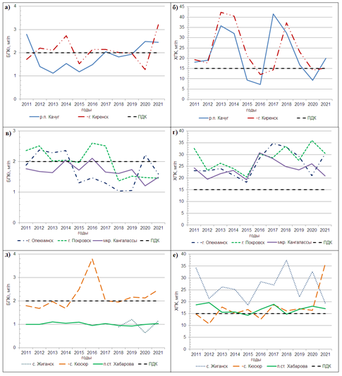
Fig. 1. Change in average annual concentrations of organic substances along the Lena River: upper – a) according to BPK5, b) by COD; average – in) according to BPK5, g) according to COD; lower – d) according to BPK5, e) by COD. The average annual concentrations of organic substances (according to BPK5) ranged from 1.12-3.21 mg/l, organic substances (according to COD) – 7.20-42.4 mg/l, phenols – 0-3 MPC, copper compounds – below MPC-3 MPC. The frequency of cases of exceeding the MPC was 25-50% of the number of water samples taken. A comprehensive assessment of the Lena River water quality in the upper reaches indicates that the water in most of the observed years was characterized as "slightly polluted"; deteriorating to the level of "polluted" – in 2012 in the range below the Kachug river, in 2012, 2013, 2018, 2020 in the range below. Kirensk; improving in some years to "conditionally clean" – in 2015 and 2016 in the range below the Kachug river, in 2020 in the range below Kirensk (Fig. 4). Good water quality is due to the low (within 20-25%) number of cases of exceeding the MPC of characteristic polluting chemicals in the water. The formation of the chemical composition of water in the middle reaches of the Lena River (from the mouth of the Vitim River to the Aldan River) is significantly influenced by carbonate rocks containing layers, layers and interlayers of gypsum, anhydrite and rock salt [5]. The water of the tributaries of the middle reaches of the Lena River is characterized by a diverse chemical composition. For the middle course of the river (from the mouth of the Vitim River to the Aldan River) on the site of the city of Olekminsk – mkr. Kangalassy, as well as for the upper course, not only organic substances (according to BPK5 and COD), phenols and copper compounds reached the characteristic level of water pollution, but iron and zinc compounds were added to them in most of the channels (fig. 3); less often manganese compounds (in the area of the Kangalassa microdistrict). 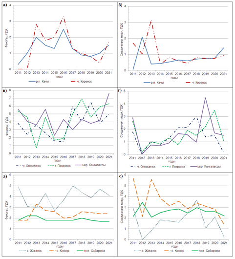
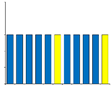
Fig. 2. Change in average annual concentrations along the Lena River: upper – a) phenols, b) copper compounds; middle – c) phenols, d) copper compounds; lower – e) phenols, e) copper compounds. Water pollution of the Lena River in the middle reaches is formed due to municipal and industrial wastewater of enterprises and organizations of adjacent cities; effluents from river fleet vessels, ports, shipping, fisheries, washing and quarry waters, wastewater from mining and gold mining enterprises engaged in water use on tributaries of the river [13, 14]. The operated treatment facilities are not always in good condition, as a result, insufficiently treated wastewater (about 40-51%) is discharged into the Lena River [15].
The average annual concentrations at the site of the city of Olekminsk – mkr. Kangalassa (middle course of the river) of organic substances (according to BPK5) ranged from 1.06-2.61 mg/l, organic substances (according to COD) – 18.2-36.1 mg/l, phenols – below MPC-7.6 MPC, copper compounds – 0-4.5 MPC, iron compounds – below MPC-1,9 MPC, zinc compounds – below MPC-4 MPC, manganese compounds – below MPC-3 MPC. The frequency of cases of exceeding the MPC was in the range of 50-100% of the number of water samples taken. (fig. 3) 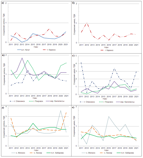
Fig. 3. Change in average annual concentrations along the Lena River: upper – a) iron compounds, b) zinc compounds; average – c) iron compounds, d) zinc compounds; lower – e) iron compounds, e) zinc compounds. The Lena River water in the middle reaches for the period 2011-2021 was consistently rated by the 3rd class in quality ("polluted" or "very polluted"). In the alignment below the city of Olekminsk in 2011, the water quality was characterized by the 4th class ("dirty" water); it improved in 2013 to the level of "slightly polluted" in the alignment below the village of Staraya Tabaga. The main source of supply of the Lena River in the lower reaches (below the mouth of the Aldan River) on the site of the village of Zhigansk – the settlement of the Khabarovsk station are surface and permafrost waters that seep through through subsurface taliks, fractured zones and less often through tectonic cracks. The widespread development of a powerful permafrost layer [9, 10] in this area significantly complicates the connection of surface waters with underground ones. As a result, the role of groundwater in river runoff is extremely limited, therefore, the influence of these waters on the chemical composition of river water is negligible [8]. Since the above–frozen waters exist in a liquid state for a limited time a year, the composition of the water in the lower reaches of the Lena River is largely determined by the composition of the transit waters of the upper and middle reaches, as well as the largest tributaries in this section of the river - the Vilyu and Aldan rivers. [5, 16] 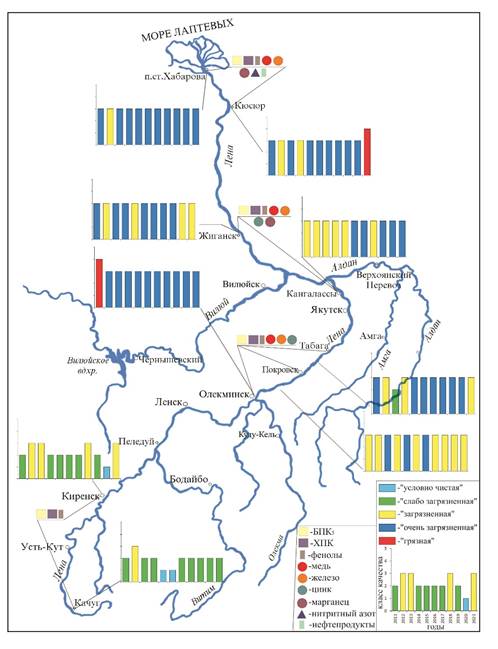
Fig. 4. Dynamics of water quality and distribution of the most common pollutants (by average annual concentrations) in water along the length of the Lena River during 2011-2021. Typical pollutants for the lower reaches of the Lena River are organic substances (according to BPK5 and COD), phenols, compounds of copper, iron, zinc and manganese, in some years nitrite nitrogen and petroleum products. The average annual concentrations of pollutants ranged from: organic substances (according to BPK5) – 0.63-3.80 mg/l, (according to COD) – 10.7-37.5 mg/l, phenols – 1.7-5 MPC, nitrite nitrogen – 1-3 MPC, petroleum products – below MPC-2 MPC; iron compounds – 1-3,6 MPC, copper – 0-5.7 MPC, zinc – below MPC-1.5 MPC, manganese – 2-4 MPC. The frequency of cases of exceeding the MPC was 50-100% of the number of water samples taken. In the long-term plan, the water of the upper reaches and the mouth of the Lena River in the period 2011-2021 was assessed as "polluted" and "very polluted", deteriorating to the level of the 4th class ("dirty") – in 2021 in the alignment below the village of Kyushur (Fig. 4) – as a result of an increase in the number of cases of excess MPC of organic substances (COD) from 60% to 100% and iron compounds from 80% to 100%. Tributaries of the Lena River The largest right tributaries of the Lena River are the Vitim River, the Olekma River, the Aldan River; the left ones are the Vilyu River. [17] The main sources of pollutants in the waters of the Vitim and Olekma river basins are wastewater from gold mining enterprises and mine water. Numerous mining enterprises processing ores of various metals are located in the Aldan River basin; there are quite large gold-bearing deposits, as well as deposits of coal and mica. The main sources of water pollution in the Vilyu River basin are wastewater from the energy industry, utilities, diamond mining, water transport; as well as objects of agriculture, gas and oil industry located along the shore. [11, 13] The studied tributaries in most of the channels are characterized by contamination with organic substances (according to COD), phenols, iron, copper and zinc compounds, whose concentrations exceeded the MPC by 50% or more of the number of water samples taken; in some years, organic substances were characteristic pollutants in some channels (according to BPK5). The most intense ecological state in the water of the Olekma river, especially in the upper reaches (within the village of Ust-Nyukzha), where the characteristic level of contamination was reached not only by the above substances, but also by ammonium nitrogen, manganese and aluminum compounds, the frequency of cases of exceeding the MPC which was observed in each selected water sample. In the long-term plan (2011-2021), the water of large tributaries of the Lena River is rated as the 3rd class of quality ("polluted" or "very polluted"). The right tributaries are the most polluted – the Olekma River and the Aldan River, where the water was mainly characterized by the 3rd class of the category "b", as "very polluted"; deteriorating to the 4th class of the category "a" ("dirty") in the upper reaches of the Olekma River within the village of Ust-Nyukzha in 2016-2021, in the upper reaches of the Aldan River below the town of Tommot in 2014. The water quality of the Vitim and Vilyu rivers [21] is consistently maintained at the level of the 3rd class, deteriorating or improving from the category "a" ("polluted") to the category "b" ("very polluted") (Table 1). Thus, water quality deteriorates in the middle and lower the Lena River, after the confluence of tributaries into it. Table 1. Water quality and characteristic pollutants of the water of individual strata of tributaries of the Lena River for the period 2011-2021.
| № p/p | Water object | Target | Quality class for the period 2011-2021. | Characteristic pollutants | | 1. | R. Vitim | below S. Romanovka (upper current) | 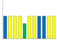
| Organic substances (according to COD), iron, copper, zinc compounds | | 2. | R. Olekma | in the village of Ust-Nyukzha (upper current) | 
| Organic substances (according to COD), ammonium nitrogen, compounds of iron, zinc, copper, manganese, aluminum | | 3. | R. Olekma | above S. Kudu-Kel (lower current) |
| Organic substances (COD), phenols, iron, copper, zinc compounds | | 4. | R. Aldan | below G. Tommot (upper current) | 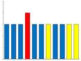
| Organic substances (according to COD), phenols, zinc, iron, copper compounds | | 5. | R. Aldan | Z.S. Verkhoyansky Transportation (lower current) | 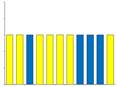
| Organic substances (according to COD), phenols, zinc, iron, copper compounds | | 6. | R. Viluy | below P. Chernyshevsky (upper current) | 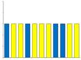
| Organic substances (according to COD), phenols, iron, copper compounds | | 7. |
R. Viluy | below Vilyuysk (lower current) | 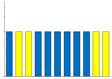
| Organic substances (according to COD), phenols, iron, copper compounds | | Symbols:  | Conclusions 1. Various physical and geographical, hydrological and climatic processes, as well as anthropogenic impact have a significant impact on the quality and chemical composition of the Lena River water and its basin. In order to track the changes taking place in these conditions, constant monitoring should be carried out, which will make it possible to make forecasts of the development of environmental situations taking into account internal and external factors. It is necessary to conduct a comprehensive analysis of long-term data on the assessment of the aquatic environment, especially in the Arctic climate. 2. In the conditions of gradually increasing development of gold ore and placer deposits on the territory of the Republic of Sakha (Yakutia) ? an increase in the maximum amount of gold production over a 100-year period [18] there is a gradual transformation of the hydrological and hydrochemical state of the aquatic environment of the Lena River basin. 3. The spatial and temporal distribution of characteristic pollutants in the water of the rivers of the Lena River basin is determined by the peculiarities of the formation of water resources in modern complex natural and climatic conditions. The change in the water content of the rivers of the Lena River basin is primarily determined by the degree of activity of local cyclonogenesis, which is the main factor of fluctuations in the water content of the rivers of the basin and changes in precipitation, this phenomenon occurs both in low-water and high-water years [14]. 4. The Lena River basin, especially in the lower reaches, is characterized by high waterlogging. Probably, due to the warming of the climate [19], swamp complexes serve as an additional source of the appearance of organic substances in the chemical composition of the surface waters of the basin (according to COD and BPK5), the content of which in concentrations exceeding MPC is found throughout the Lena River; at the same time, the maximum concentrations of organic substances (according to COD) in different years reached 36.9-90.7 mg/l, organic substances (according to BPK5), respectively, 3.93-3.86 mg/l. 5. In the conditions of the Arctic climate, the seasonal distribution of organic substances in surface waters was insignificant. 6. The presence of phenols, petroleum products, and metal compounds in the surface waters of the Lena River basin most likely indicates a significant role of the anthropogenic component in the formation of the chemical composition of river water. 7. Analysis of the dynamics of water quality along the Lena River revealed a deterioration of water quality in the middle and lower reaches, after the confluence of large tributaries into it; over a long period (2011-2021), the deterioration of the river water to the 4th quality class ("dirty") was noted [20]. 8. During 2011-2021, the water of the rivers of the Lena River basin in most years was evaluated by the 3rd satisfactory quality class.
References
1. Chevychelov, A. P., Alekseev, A. A., & Ermolaeva, S. V. (2021). Genesis, classification and diversity of permafrost soils of Central Yakutia. Soil as a link in the functioning of natural and anthropogenically transformed ecosystems: materials of the V International scientific and Practical conference dedicated to the 90th anniversary of the Department of Soil Science and Assessment of Land Resources of the ISU and Baikal Day (Irkutsk, August 23-29, 2021) Irkutsk: Irkutsk State University, pp. 201-205. (in Russian)
2. Chevychelov, A. P., Alekseev, A. A., & Ermolaeva, S. V. (2021). Diversity of permafrost soils of Central Yakutia. Diversity of soils and biota of Northern and Central Asia: Materials of the IV All-Russian conference with international participation dedicated to the Year of Science and Technology in the Russian Federation and the 40th anniversary of the Institute of General and Experimental Biology SB RAS (Ulan-Ude, June 15-18, 2021) Ulan-Ude: Buryat Scientific Center of the Siberian Branch of the Russian Academy of Sciences, pp. 515-517. (in Russian)
3. The Far North: Plant biodiversity and Ecology of Yakutia. Plant and Vegetation 3. (2010). Springer Science + Business Media B.V., 390 p. doi:10.1007/978-90-481-3774-9
4. Pastukhov, A., Marchenko-Vagapova, T., Loiko, S., & Kaverin, D. (2021). Vulnerability of the Ancient Peat Plateaus in Western Siberia. Plants. MDPI AG. Retrieved from http://dx.doi.org/10.3390/plants10122813.
5. Surface water resources of the USSR. (1972). Ed. Protasyeva M.S. L.: Hydrometeoizdat, Vol. 17. 651 p. (in Russian)
6. National Atlas of soils of the Russian Federation. (2011). Moscow: Astrel. AST, 632 p.: A92 maps, fig. (in Russian)
7. Scientific and applied reference book: Long-term fluctuations and variability of water resources and the main characteristics of the flow of rivers of the Russian Federation. (2021). St. Petersburg: REAL LLC, 190 p. (in Russian)
8. Shepelev, V.V., & Pavlova, N.A. (2014). The main components of the underground feeding of the rivers of Yakutia (Science and Education), 2, 117-120. (in Russian)
9. Fedorov A.N., Vasilyev N.F., Torgovkin Y.I., Shestakova A.A., Varlamov S.P., Zheleznyak M.N., Shepelev V.V. et al. (2018). Permafrost-Lanscape Map of the Sakha (Yakutia) on Scale 1:1,500,000. Geosciences, 8 (465). 17 p. doi:10.3390/geosciences8120465
10. Fedorov A.N. (2022). Permafrost Landscape Research in the Northeast of Eurasia. Earth, Vol. 3(1). P. 460–478. doi:10.3390/earth3010028
11. Yearbook "The quality of surface waters and the effectiveness of water protection measures carried out on the territory of the activity of the Irkutsk UGMS Federal State Budgetary Institution for 2021. Irkutsk, 2022. pp. 46-47, 68-70. (in Russian)
12. State report on the state and environmental protection in the Irkutsk region in 2021. Izhevsk: Print LLC, 2022. 252 p. (in Russian)
13. Yearbook "The quality of surface waters and the effectiveness of water protection measures carried out on the territory of the activity of the Federal State Budgetary Institution "Yakut UGMS" for 2021. Part 1. Yakutsk, 2022. 435 p. (in Russian)
14. State Report "On the state and environmental protection of the Republic of Sakha (Yakutia) in 2021". Ministry of Nature Protection of the Republic of Sakha (Yakutia). Yakutsk, 2022. 776 p. (in Russian)
15. Rodnina, N.V., & Solomonov, A.I. (2021). Ecological situation in the Republic of Sakha (Yakutia). Academic Bulletin of the Yakut State Agricultural Academy. No. (20). pp. 51-57. (in Russian)
16. Water resources of Russia and their use. Ed. Shiklomanova I.A., GGI, St. Petersburg, 2008. pp. 94-95. (in Russian)
17. Yearbook "Surface water quality of the Russian Federation for 2021". Rostov-on-Don: GHI, 2022. 620 p. (in Russian)
18. Batugina, N. S., & Nogovitsyn, R. R. (2021). Gold mining in the Republic of Sakha (Yakutia). Trends and prospects of development. Mineral resources of Russia. Economics and management. No. 1-6(175). pp. 75-80. (in Russian)
19. Ivanov, V. A., & Rozhin, I. I. (2021) Modeling of degradation of permafrost rocks during climate warming in Central Yakutia for the next 300 years. Modern High-tech Technologies. No. 10. pp. 41-47. doi:10.17513/snt.38852 (in Russian)
20. Chekmareva, D.P., & Lobchenko, E.E. (2023). Dynamics of the Lena River water pollution level for the period 2012-2021. Natural resource potential and ecological rehabilitation of degraded landscapes. Collection of materials of the International Scientific and Practical Conference (Grozny, March 17–18, 2023). Grozny: publishing house of the Chechen State University named after A.A. Kadyrova". pp. 344-347. doi:10.36684/86-1-2023-344-347. (in Russian)
21. Chekmareva, D.P., & Romanyuk, O.L. (2023). The current state of the water pollution level of the Vilyu River basin. Ecology and Nature management: trends, models, forecasts, applied aspects / Materials of the National Scientific and Practical Conference (March 16, 2023). Ryazan: Publishing House of the Ryazan State Agrotechnological University. pp. 257-261. (in Russian)
Peer Review
Peer reviewers' evaluations remain confidential and are not disclosed to the public. Only external reviews, authorized for publication by the article's author(s), are made public. Typically, these final reviews are conducted after the manuscript's revision. Adhering to our double-blind review policy, the reviewer's identity is kept confidential.
The list of publisher reviewers can be found here.
The subject of the study is, in the author's opinion, an assessment of the influence of the peculiarities of the formation of water resources and the quality of surface waters of the Lena River basin. The methodology of the study is not specified in the article, but based on the analysis of the article, it can be concluded that the methods of chemical analysis of macronutrient composition in frozen rocks, as well as the analysis of literary data, are used. Judging by the illustrative material, the author has undertaken an analysis in order to study the spatiotemporal changes in the content of chemicals in the surface waters of the Lena River basin, statistically processed hydrochemical data for the period 2011-2021 were used. The relevance of the topic raised is unconditional and consists in obtaining information about the significant impact on the qualitative and chemical composition of the waters of the Lena River basin. In order to track the changes taking place in these conditions, it is stated that there is a need for constant monitoring, which will make it possible to make forecasts of the development of environmental situations, taking into account internal and external factors. It is necessary to carry out a comprehensive analysis of long-term data on the assessment of the aquatic environment, especially in the Arctic climate in conditions of gradually increasing development of gold ore and placer deposits in the territory of the Republic of Sakha (Yakutia). The scientific novelty lies in the author's attempt to draw a conclusion based on the conducted research on comparing the variability of the composition of waters to understand the mechanism of reaction to changes in weather and climatic conditions and geochemical migration of trace elements. The author makes a conclusion about the distribution of characteristic pollutants in the water of the rivers of the Lena river basin, due to the peculiarities of the formation of water resources in modern difficult natural and climatic conditions. Style, structure, content the style of presentation of the results is quite scientific. The article is provided with rich illustrative material reflecting the process of pollution formation in water and the features of runoff. The author designed the tabular material in the form of graphs and diagrams, which made it possible to increase the visibility and reasonableness of the presented materials. However, there are a number of issues, in particular: The author of the article should highlight sections of the article for a better perception, in addition to the target setting, specify research methods and tasks. The author of the article needs to generalize the information provided by removing unnecessary citations from the content of the article, for example, literary sources are quoted twice in the conclusion and conclusions based on the research materials, it is necessary to indicate the author's contribution when drawing up drawings and diagrams. The bibliography is very exhaustive for the formulation of the issue under consideration, but does not contain references to normative legal acts and methodological recommendations on the geochemical analysis of the characteristics of waters and sources of pollution. The appeal to the opponents is presented in identifying the problem at the level of available information obtained by the author as a result of the analysis. Conclusions, the interest of the readership in the conclusions there are generalizations that made it possible to apply the results obtained. The target group of information consumers is not specified in the article.
Link to this article
You can simply select and copy link from below text field.
|
|


