|
MAIN PAGE
> Back to contents
Arctic and Antarctica
Reference:
Vasil'chuk A.C., Vasil'chuk Y.K.
Possibility using carbon-to-nitrogen ratio as a criterion for palsa and lithalsa distinguishing
// Arctic and Antarctica.
2023. № 3.
P. 52-72.
DOI: 10.7256/2453-8922.2023.3.44176 EDN: VKRSQW URL: https://en.nbpublish.com/library_read_article.php?id=44176
Possibility using carbon-to-nitrogen ratio as a criterion for palsa and lithalsa distinguishing
Vasil'chuk Alla Constantinovna
Doctor of Geography
Leading Research Fellow, Laboratory of Geoecology of the Northern Territories, Faculty of Geography, Lomonosov Moscow State University
119991, Russia, g. Moscow, Leninskie Gory, GSP-1, 1,, geograficheskii fakul'tet, NIL geoekologii Severa

|
alla-vasilch@yandex.ru
|
|
 |
Other publications by this author
|
|
|
Vasil'chuk Yurii Kirillovich
ORCID: 0000-0001-5847-5568
Doctor of Geology and Mineralogy
Professor, Department of Landscape Geochemistry and Soil Geography, Lomonosov Moscow State University, Faculty of Geography
119991, Russia, Moscow, Leninskie Gory str., 1, of. 2009
|
|
vasilch_geo@mail.ru
|
|
 |
|
DOI: 10.7256/2453-8922.2023.3.44176
EDN: VKRSQW
Received:
29-09-2023
Published:
19-10-2023
Abstract:
The palsa and lithalsa are reliable indicators of the presence of permafrost, especially on the its southern border. The subject of the study is the consideration of the C/N ratio in the peat of the palsa and the litter and humus horizon of the lithalsa as a criterion for the separation of the palsa and lithalsa. The palsa near the Yeletskaya village in the Bolshezemelskaya tundra and the lithalsa in the Southern Transbaikalia near the Preobrazhenka village and in the valley of the Sentsa in the Eastern Sayan are considered. The history of the study of lithalsa and palsa in Russia at the beginning of the twentieth century is considered also. It was found that the nitrogen content in the surface layers of the lithalsa (0.45-1.73% in the valley of the Sentsa River and 0.47-2.01% near the Arachley Lake) is approximately in the same range as in the surface horizons of the palsa, regardless of the permafrost region. The results of the carbon and nitrogen content determining, as well as their ratios in the peat cover of the palsa are summarized. In contrast to lithalsa, the carbon content in the peat horizons of the palsa and flat-hummock peatlands is many times higher than the values obtained for both surface and buried organic horizons of the lithalsa. The value of C/N less than 13 has not been recorded for the peat cover of palsa, this indicator for lithalsa never exceeds 10-12.
Keywords:
permafrost, palsa, lithalsa, Holocene, peat, carbon, nitrogen, Bolshesemelskaya tundra, Sayan, Transbaikalia
This article is automatically translated.
You can find original text of the article here.
Introduction Palm peatlands on the scale of the biosphere contain a significant carbon reserve (C), therefore, their dynamics in the biosphere have important consequences for the global carbon cycle, the dynamics of bumpy peatlands, as well as nitrogen and carbon content indicators in the Arctic and Subarctic arouse increased interest among researchers in connection with the assessment of greenhouse gas emissions and changes in the productivity of tundra landscapes, and also with the fact that the heave mounds – palza and litalza - are a reliable indicator of the presence of permafrost rocks, especially on the southern border of their distribution. However, the uncertainties of estimates of carbon dynamics at different time scales, different approaches require further study of these complex natural systems. According to the definition given in Wikipedia: palza is peat mounds (hills) with a permafrost peat-mineral core, litalza is mounds (hills) formed under the influence of frost in areas of permafrost with mineral—rich soils, where a lens of perennial ice has formed in the soil. Definitions from the international geocryological dictionary-reference[1]: palm - peat mounds (hills) of permafrost, the core of which consists of alternating layers of segregation ice, peat or mineral soil material. The explanation of the term minerogenic palsa states that S. Harris[2] described the sequence of stages of development of finger-shaped hills developed in mineral soils in the Fox Lake area (Yukon), for which he proposed the name "litalza". He suggested that a new name is needed, since the processes of heat and moisture transfer in mineral soils differ from those in peat soils. Domestic geocryologists had not previously isolated litales, and in cases when mineral mounds were encountered, they were called bumpy marys, burial mounds, etc. [3,4,5]. Similar in structure to the litalz are the hillocks-tabelers, widely distributed in the intermountain basins of the Altai. It must also be admitted that the term litalza did not immediately take root in English-language literature. Other terms have been used for a long time: “minerogenic fingers”[6], “mineral fingers”[7], “finger-like hillock”[2], “cryogenic mounds”[8] and “mineral permafrost hillock”[9]. And only after the work of A. Pissar[10], the ice-mineral mounds prefer to be called lithalsa. The first to use the term litalza in relation to the Russian ice-mineral mounds of Ivakhan and colleagues studied in the valley of the Akkol River in Altai[11]. Yu.K. Vasilchuk first met relatively low mineral mounds (litalza up to 1 m high located directly between the railway tracks) in paragenesis with palza near the village. Khanovey, near Vorkuta in 2002, however, did not pay due attention to this and recorded it only in a 2016 publication: "Heaving mounds - both peat and mineral - are frozen..."[12]. The reason for a more attentive attitude to the mineral heave mounds was a detailed study of ice-ground deposits in the thickness of a mineral permafrost mound (litalza) in the valley of the Sentsa River in Western Buryatia [13,14]. The exposed ice-ground deposits were the cores of injection–segregation type bulges – litalza - and formed in the late Holocene. Recognition of heave mounds and their type: palza, litalza or pingo-bulgunniakhi is not an easy task, since their morphology and morphometry are quite close. In both cases these are convex mounds with a height from 0.5 to 5-8 m (rarely 10 m or more - in pingos) of rounded or oval (elliptical) outline in plan (usually the first tens of meters in diameter. An important criterion for separation is the presence of peat cover, often thick (up to 5 meters or more) at the finger (Fig. 1), and its often almost complete absence in the sections of litalza (Fig. 2) and pingo. 
Fig. 1. A finger covered with a thick layer of peat, near the village of Yeletsky. Photo by Yu.K. Vasilchuk 
Fig. 2. Litalza in the valley of the Sentsa river. Photo by J.Y. Vasilchuk The objects of this study are litalza in Southern Transbaikalia and Eastern Sayan, as well as palza in the Bolshezemelskaya tundra. The main objective of the study is to assess the similarities and differences in the distribution of nitrogen and carbon in these cryospheric objects. Climatic characteristics of the study areas Palza at the village of Yeletsky. The studied array of [15-17] typical fingers (see Fig. 1, Fig. 3) located in the European part Polar?Ural (67°02' s.w. and 64°12' v.d.) near the village of Yeletsky, 52 km south of Vorkuta. The climate is subarctic, characterized as unstable with heavy snowfalls, blizzards and frosts. The period of negative temperatures is from October to March. According to the data of the Yeletskaya weather station in the interval 1959-2022, the minimum average annual temperature was recorded in 1998 -8.3?C; the average value of this indicator is -4.9?C, the maximum is -0.8?C in 2020. The lowest average daily temperature was observed in February 1966 ? 30 °C, and February 1998 -29.6 °C; the average daily January temperature was -19.7 °C, the average temperature of the three winter months -18.2 °C. The maximum average daily temperature of +18.3 °C was recorded in July 2007, the average July temperature was +13.7 °C, during the observation period there was no recorded average daily July temperature below +7.6 °C, which was observed in 1997, the average temperature of the three summer months was +10.5 °C. 
Fig. 3. Palza at the village of Yeletsky. Photo by Yu.K. Vasilchuk Litalza in the valley of the Sentsa river. The studied litalza massif on the left bank of the Sentsa River (52?39.827' N, 99?29.858' E) is located within the lowered lake basin in the southeast of the Eastern Sayan on the Okinsky plateau. The climate within the Okinsky Plateau is sharply continental. According to the nearest weather station Orlik (52°50's.w. 99°82' in.D. altitude above sea level - 1375 m -http://www.pogodaiklimat.ru/history/29998.htm ): the average annual temperature for the period 1934-2022 is in the range from -2.7 °C to -6.6°C, the average January temperature is -24.5 °C (from -33.2 to 17.1 °C), the absolute minimum is -46.9 °C, the average temperature of the warmest month of July is 13.4 °C (from +11.1 to +16.3 °C), the absolute maximum is +35.8 °C. The average annual temperature of frozen rocks varies within -2.1 ... -8.5 °C, sometimes rising to -0.5, -1 ° C. The seasonally thawing layer on the interfluvial spaces has a thickness of 1.0-1.5 m, reaching 3.5 m on the southern slopes. On the surface of the first terrace of the Sentsa River (absolute height 1387 m), large castalzas with a height of 4 to 7-9 m were studied and drilled. The temperature of the soils of one of the largest lithals (7 m high) according to the thermometry of a deep well is -2.1 ° C (at a depth of 10 m), and -1.0 ° C (at a depth of 20.4 m). Litalza at the village . Preobrazhenka in the Trans-Baikal Territory are common in the coastal zone of the lake.Arachley (52 °13c.w., 113 °48 v.d.) in the Beklemishevskaya basin (a tectonic depression of the Trans-Baikal type). The climate is characterized as sharply continental. The area is characterized by large daily and seasonal temperature fluctuations, a high level of solar radiation (the annual amount of the radiation balance is 30.6 kcal /cm2). According to the nearest weather station Burgen): the average annual temperature for the period 1937-2022 is in the range from -1.5 °C to -6.2 °C, the average value is -3.5 °C, the average January temperature is -27.2 °C (from -34.8 to -22.3 °C), the absolute minimum is -52 °C.the average temperature of the warmest month of July is +17.1 °C (from +13.5 to +20.3 °C). the absolute maximum reaches +34 °C. The duration of the frost-free period is 70-90 days, with a very late transition of stable temperatures through +10 ° C. The duration of the growing season is about 130 days. 350-380 mm of precipitation falls in this area per year. Of these, the growing season accounts for from 280 to 320 mm (precipitation is most abundant in July and August). In winter, precipitation ranges from 1 to 5 mm, so the height of the snow cover does not exceed 10-15 cm, on wooded ridges and ridges - 150 cm. Permafrost rocks are noted on the northern slopes, the greatest MMP capacity is noted in the falls. Methods for measuring the content of organic carbon (C) and nitrogen (N) To determine the content of organic carbon (C,) and nitrogen (N), samples of peat and soil horizons with a volume of about 1-0.5 cm3 were taken from the sections of the palza and litalza. The samples were freeze-dried for two days, then crushed in an agate mortar and dried again at 60 °C for 2 hours. The samples were placed in foil capsules, weighed with an accuracy of 5 digits. Measurements of the percentage of nitrogen and carbon were carried out in the Laboratory of Landscape Geochemistry of the Department of Landscape Geochemistry and Soil Geography of the Geographical Faculty of Lomonosov Moscow State University. The measurements were carried out on the VARIO EL III V4.01 CHNS analyzer 20.Aug. 2002, Elementar Analysen systeme GmbH, Germany. Sulfanylic acid (Merck) was used as a standard with values of N = 8,090%, C = 41,610%. Results Litalza at the village . Preobrazhenka. Litalza were studied by O.E. Maksimova[18] on the territory of the Ivano-Arakhlei reserve 300 m south of S.Preobrazhenka in the Trans-Baikal Territory (52 ° 13c.w., 113 ° 48 v.d.). O.E. Maksimova, with the assistance of D.M.Shesternev, described in detail two litals: one 2.5 m high (Fig. 4), the other 1.2 m high. 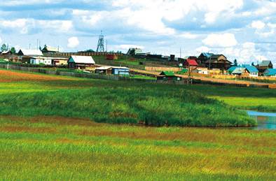
Fig. 4. Litalza near the village. Preobrazhenka. Photo by O.E.Maksimova For temperature observations, D.M. Shesternev and colleagues drilled a well at the top of the largest 2.5-meter finger. In its section from top to bottom are opened: 0 – 2 cm – turf; 2 – 25 cm – gray-brown powdery slightly torn sandy loam with a large number of roots; 25 – 41 cm – gray-brown powdery slightly torn sandy loam with a small number of roots; 41 – 63 cm – dense brown powdery loam with the inclusion of roots; 63 – 93 cm – very dense brown loam; 93 – 100 cm – very dense gray-beige loam. The whole soil is very dry, from the surface the hillock is covered with a dusty slightly detached sandy loam, underlain by loam. Two pits were laid in a small hillock, the soil in the section of the hillock is wet and strongly torn off. In the section from the surface there is also a sandy loam, which turns into loam below. In the well at the top of the largest heaving hill, negative ground temperatures are traced to a depth of 4.5 m on the slope of the hillock (Fig. 6) and to a depth of 7.8 m at its top. Three pits were laid in a large hillock: in the upper, middle and lower parts (Fig. 5). 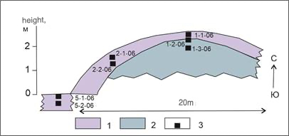
Fig. 5. The profile of the largest hillock in the system of heave mounds in the lake basin. Arachley next to D. Preobrazhenka, Transbaikalia (according to O.E.Maksimova[18]): 1 – gray-brown detached sandy loam with roots 2 – brown powdery loam, 3 – sampling points 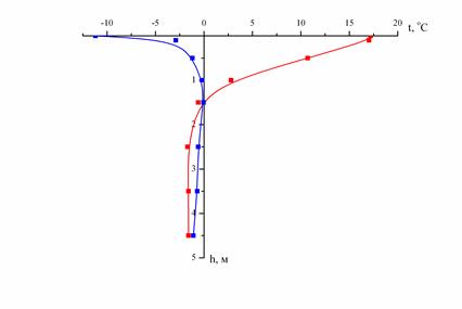
Fig. 6. The graph of the temperature distribution in the litalz section on its slope near the lake.Arachley, Trans-Baikal Territory (from O.E.Maksimova[18]). Cryogenic structure of hillocks Litalza in the valley of the Sentsa river. On the surface of the first terrace of the Sentsa River (absolute height 1387 m), large castalzas with a height of 4 to 7-9 m were studied and drilled. The roof of the MMP is fixed at a depth of 0.85-1.5 m (Fig. 7). The upper part of the sections of the studied litals is represented by light brown sandy loam, which is underlain by bluish-gray loam at a depth of 6.3 m. The apparent iciness of the soil increases from a depth of 1.35 m . Below, the section is composed of ice-ground with basal, sometimes layered large-leaf, cryotexture. In numerous interlayers and lenses with a capacity of 3-5 cm, the ice is transparent with bubbles of a rounded (diameter 0.5-1.0 mm) and elongated shape. In places, the ice is white and opaque. At a depth of 6.3 m, a clear contact with bluish-gray sandy loam was recorded, which lies to a depth of 8 m. From a depth of 8 m, the sandy loam is replaced by bluish-gray loam, contains layers of transparent ice (up to 5-6 cm). The thickness of the loam interlayers is 6-7 cm, their cryotexture is massive. 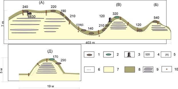
Fig. 7. Litalz profiles in the Sentsa River valley. According to Vasil'chuk et al.[19] with additions: 1 – lenses of buried peat; 2 – decomposed wood; 3 – wood residues (roots, branches); 4 – 14 years old, cal. years ago; 5 – litalz index; 6 – the boundary of the seasonal-thawed layer; 7 – lake-river frozen loam; 8 – seasonal-thawed layer; 9 – ice core litalz. 10 – sampling points for the content of C and N. Palza in the Bolshezemelskaya tundra near the village of Yeletskaya. Within the convex-bumpy massif in the area of the village of Yeletsky (67°16's.w., 63°39' v.d.), heave mounds with a height of 1.5 to 5 m were studied in detail. Samples were taken from sections located in various geomorphological positions: on the peaks, slopes and at the foot of the finger, as well as in the hollows on the tops of the hillocks. As an example of a typical finger for this localization, an incision of a bulge with a height of 2.5 m (18El?VC.) is given. The maximum depth of thawing at the top of the hillock (at the end of September) was 0.65 m. The 18El?VC finger had a flat (and not convex, like most of the mounds on this array) surface. This hillock in the marginal part is eroded by a lake, peat was selected from the exposed peat wall for 14 C dating, as well as for determining the carbon and nitrogen content (Fig. 8). 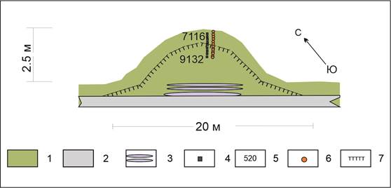
Fig. 8. Profile of the 18El?VC finger near the village of Yeletskaya: 1 – peat; 2 – gray loam; 3 – ice core; 4 – sampling points at 14C; 5 –14C age, cal. years ago; 6 – sampling points for the content of C and N; 7 –the boundary of the seasonal melt layer. Organic carbon (C,) and nitrogen (N) content Litalza in the valley of the Sentsa river. Litalza on the surface of the first terrace p .Senets are characterized by the following indicators: in the litter-peat and humus soil horizons, the nitrogen content (N) is 0.45?1.73%, the average value is 0.83%, the carbon content (C) is 2.52-11.56%, the average value is 6.86%, the C/N ratio is in the range of 6.2?12.9, the average value is 9.33 (Table. 1). Table 1. Carbon and nitrogen content of litter-peat and humus soil horizons of litalza in the Sentsa river valley | № | Field number | horizon and depth of selection, cm |
N,% | C,% | C, mol | N,mol | Ca/Na | | 1 | Jse-16-2 | About 0-3 | 0,80 | 5,64 | 0,47 | 0,06 | 8,24 | | 2 | Jse-16-3 | O 0-3 | 0,70 | 5,65 | 0,47 | 0,05 | 9,46 | | 3 | Jse-16-9 |
O 0-3 | 1,33 | 11,56 | 0,96 | 0,1 | 10,13 | | 4 | Jse-16-14 | O0-3 | 0,47 | 2,52 | 0,21 | 0,03 | 6,24 | | 5 | Jse-16-16 | About 0-3 (10) | 0,73 | 5,20 | 0,43 |
0,05 | 8,27 | | 6 | Jse-16-22 | TO 0-27 | 1,73 | 11,25 | 0,94 | 0,12 | 7,57 | | 7 | Jse-17-2 | AU 0-5(14) | 0,47 | 3,94 | 0,33 | 0,03 | 9,77 | | 8 | Jse-17-4 | Aurig 0-28 | 0,86 |
6,85 |
|
Other our sites:
Official Website of NOTA BENE / Aurora Group s.r.o.
|
Copyright protected by law of the Russian Federation.
Any materials may be published only with link to the source.
All violations of law are punishable by law.
© NB-Media.
|

|
|